
Climate
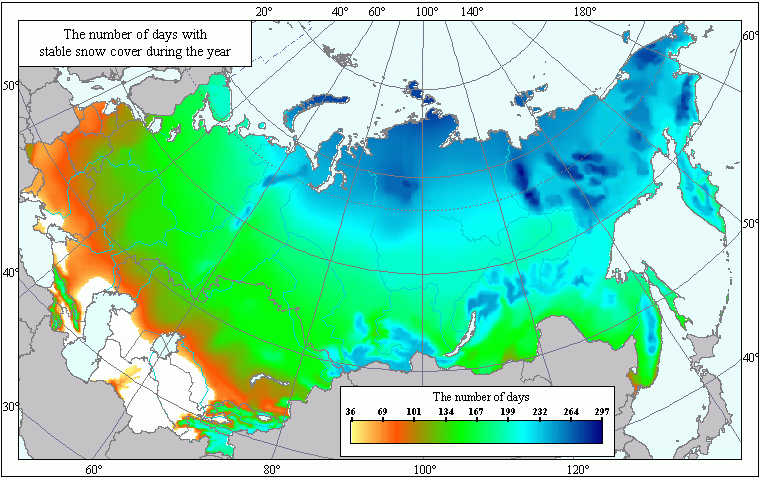
Mean Annual Number of Days with Stable Snow Cover .
 Download GIS-layers
Authors:
A.N. Afonin, K.L. Lipiyainen, Y.S. Li, V.Y. TsepelevCompilation date:
May 2005.Scale:
10 km/pixMap's precision:
The map contains the mean annual number of days with stable snow cover for patches of the Earth's surface with the area of 10 x 10 km.Projection:
"Albers Equal Area for the USSR":ref. system : Albers Equal Area Conic for Russia
projection : Albers Equal Area Conic
datum : Pulkovo 1942 (S42)
delta WGS84 : 28 -130 -95
ellipsoid : Krasovsky
major s-ax : 6378245.000
minor s-ax : 6356863.019
origin long : 100
origin lat : 0
origin X : 0
origin Y : 0
scale fac : na
units : m
parameters : 2
stand ln 1 : 44
stand ln 2 : 68
Main content:
A bitmapped map containing the mean annual number of days with stable snow cover.Classifier precision:
Mean annual number of days with stable snow cover is represented as a number of days. In the source maps for this map the isolines of stable snow cover's formation and dissolution are represented with 10 days' pitch.Map compilation procedure:
The map has been compiled on the basis of the data obtained from the Map of the Average Dates of Stable Snow Cover's Formation and the Map of the Average Dates of Stable Snow Cover's Dissolution from the Climate Atlas of the USSR (Climate Atlas of the USSR, 1960). The maps were vectorized and the number of days with stable snow cover was calculated with rasterized algebraic techniques.Data sources:
Climate Atlas of the USSR, vol. 1, Davitay, F.F. ed., Moscow, Gidrometeoizdat, 1960.Climate Handbooks. Air Humidity, Atmospheric Precipitation and Snow Cover. Issues 1-34. - Leningrad: 1965-1975.
Rights and copyrights not cited.