
Climate
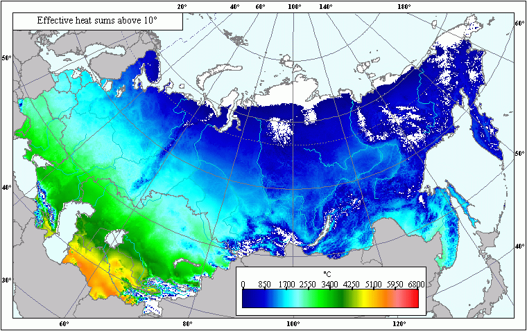
Effective heat sums above 10°C .
 Download GIS-layers
Zoom in the Map
Authors:
Afonin, A.N., Li, Y.S., Lipiyaynen, K.L., Tsepelev, V.Y.Compilation date:
15.10.2005.Scale:
10 km/pixMap's precision:
The map contains effective heat sums above 10°C for patches of the earth's surface with an area of 10 x 10 km. The layer has been derived by way of calculation using layers of average monthly air temperatures.Projection:
"Albers Equal Area for the USSR":ref. system : Albers Equal Area Conic for Russia
projection : Albers Equal Area Conic
datum : Pulkovo 1942 (S42)
delta WGS84 : 28 -130 -95
ellipsoid : Krasovsky
major s-ax : 6378245.000
minor s-ax : 6356863.019
origin long : 100
origin lat : 0
origin X : 0
origin Y : 0
scale fac : na
units : m
parameters : 2
stand ln 1 : 44
stand ln 2 : 68
Main contents:
A bitmapped map containing effective heat sums above 10°C.Classifier precision:
Effective heat sums are expressed in degrees Centigrade.Map compilation procedure:
The layer has been derived by way of calculation using layers of average monthly air temperatures (Afonin at al., 2006). The calculation followed the general procedure (Losev, 1994) used in the Idrisi program, which involves macro programming. "-100" marks the pixels outside the atlas.Data sources:
Afonin, A.N., Lipiyaynen, K.L., Tsepelev, V.Y. (St. Petersburg State University, Faculty of Geography, St Petersburg, Russia). 2006. Maps of average annual air temperature. In: Afonin, А.N.; Grinn, S.L.; Dzyubenko, N.I.; Frolov, А.N. Interactive Atlas of Useable Plants, Their Pests and Ecological Factors in Russia and Neighboring Countries. [Internet-version 1.0]. St. Petersburg, Russia. St. Petersburg State University, Faculty of Geography. 2006, Jan. https://agroatlas.ruLosev, А.P. 1994. Training for Agrometeorological Provision for Plant Cultivation St. Petersburg, 244 p.