
Climate
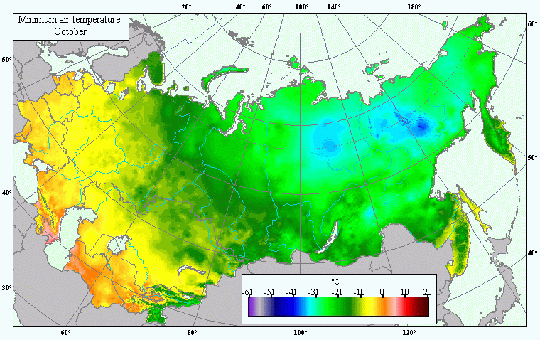
Map of mean annual minimum air temperatures in October .
 Download GIS-layers
Zoom in the Map
Authors:
A.N. Afonin, K.L. Lipiyaynen, V.Y. TsepelevCompilation date:
30.05.2005.Scale:
10 km/pixMap's precision:
The map contains averaged values of mean annual minimum air temperature for patches of the earth's surface with an area of 10 x 10 km.Projection:
.Alber.s equal-area projection for the USSR.ref. system : Alber's Equal Area Conic for Russia
projection : Alber's Equal Area Conic
datum : Pulkovo 1942 (S42)
delta WGS84 : 28 -130 -95
ellipsoid : Krasovsky
major s-ax : 6378245.000
minor s-ax : 6356863.019
origin long : 100
origin lat : 0
origin X : 0
origin Y : 0
scale fac : na
units : m
parameters : 2
stand ln 1 : 44
stand ln 2 : 68
Main content:
A bitmapped map. The map contains mean annual minimum air temperatures for October.Classifier precision:
Temperature is expressed in degrees Centigrade to a tenth of a degree.Map compilation procedure:
The map was compiled using air temperature readings from a network of weather stations within the former USSR. Mean annual monthly minimum air temperatures were taken from climate handbooks (Climate Handbook, 1964-1970). The data from 4,620 weather stations have been used to create the map. The bitmapped temperature layer was created using the Kriging climate simulation technique (Hart et al., 1996). The map takes into account the influence on air temperature exerted by seas and other large bodies of water. Thus, coastal and mainland weather stations were dealt with separately. All weather stations located less than 30 km away from the coast were considered coastal. The main features taken into consideration during mapping were the station's altitude above sea level, its latitude and longitude and the values of the average air temperature. The multiple regression equation allowed us to determine the relationship between minimum air temperature and the station's altitude, as well as the relationship between the latitude and longitude of the site and average air temperature. Values for mainland and coastal stations were calculated separately. The difference between actual and calculated values was the remainder, which was interpolated over the whole scanned area in accordance with the Kriging method. The temperature matrix was calculated using the Idrisi program (Image Calculator module) in accordance with the obtained regression formula, in which corresponding latitudinal and longitudinal matrices with the station's altitude above sea level in meters and the average air temperature were used as substitutes for latitude and longitude values. The interpolated remainder's layer was added to the calculated layer. Matrix cells' altitudes were determined using the SRTM digital relief model. The resulting field of minimum temperatures was derived by merging the resulting mainland and coastal fields.Data sources:
Climate Handbook. Temperature. Part 2, Issues 1-34. 1964-1970.Hart T., Greene S., Afonin A. 1996. Mapping for Germplasm Collections: Site Selection and Attribution / ASPRS Annual meeting in Baltimore, Maryland. Web-paper. April, 1996.
SRTM (Shuttle Radar Topography Mission) 3 arc second (90 meter) SRTM DTED(r) Level 1 "Finished" data derived from SRTM IFSAR data/ http://edc.usgs.gov/products/elevation.html