
Soils
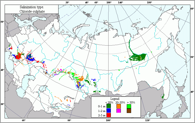
Chloride and Sulfate Soil Salinization .
 Download GIS-layers
Zoom in the Map
Authors:
Khitrov N.B., Kalinina N.V., Krylova E.S., Rukhovich D.I., Vilchevskaya E.V.Compilation date:
10.01.2004.Scale:
10 km/pixMap's precision:
The map contains information on chloride and sulfate soil salinization for patches of the Earth's surface with the area of 10 х 10 km.Projection:
"Albers Equal Area for the USSR":ref. system : Albers Equal Area Conic for Russia
projection : Albers Equal Area Conic
datum : Pulkovo 1942 (S42)
delta WGS84 : 28 -130 -95
ellipsoid : Krasovsky
major s-ax : 6378245.000
minor s-ax : 6356863.019
origin long : 100
origin lat : 0
origin X : 0
origin Y : 0
scale fac : na
units : m
parameters : 2
stand ln 1 : 44
stand ln 2 : 68
Main content:
A bitmapped map containing information about chloride and sulfate soil salinization.Classifier precision:
Chloride and sulfate soil salinization's degree is estimated by the eight-point scale which takes into account salinization percentage and depth:0 : no chloride and sulfate salinization
2 : < 20 %, 0-1 m
3 : < 20 %, 1-2 m
4 : 20-50%, 0-1 m
5 : > 50 %, 0-1 m
6 : < 20 %, 2-5 m
7 : 20-50%, 1-2 m
8 : > 50 %, 1-2 m
Map compilation procedure:
The chloride and sulfate soil salinization layer has been obtained on the basis of the generalized Russian Soils Map (1993) (scale - 1: 4 000 000) which was combined with the database linking the skeleton of the soil types' map with the data about salinization degree of soils of the given type.Data sources:
Russian Soils Map. scale 1 : 4 000 000. Roskartografiya Publishers, 1993.Map of chemical typs of salted soils, USSR. Moscow, 1976