
Soils
Soil Thickness .
 Download GIS-layers
Authors:
Fiodorov, A.S., Rukhovich, D.I., Vilchevskaya, E.V.Compilation date:
12.06.2005.Scale:
10 km/pixMap's precision:
The map contains information on soil thickness for patches of the Earth's surface with the area of 10 х 10 km.Projection:
"Albers Equal Area for the USSR":ref. system : Albers Equal Area Conic for Russia
projection : Albers Equal Area Conic
datum : Pulkovo 1942 (S42)
delta WGS84 : 28 -130 -95
ellipsoid : Krasovsky
major s-ax : 6378245.000
minor s-ax : 6356863.019
origin long : 100
origin lat : 0
origin X : 0
origin Y : 0
scale fac : na
units : m
parameters : 2
stand ln 1 : 44
stand ln 2 : 68
Main content:
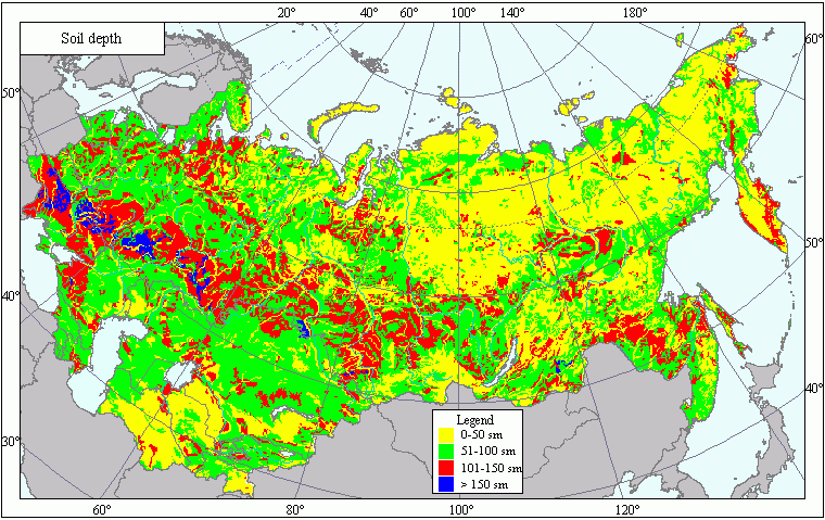
A bitmapped map containing information on soil thickness.Classifier precision:
Soil thickness is estimated by the four-point scale:1 : 0-50 cm
2 : 51-100 cm
3 : 101-150 cm
4 : > 150 cm
Map compilation procedure:
The soil thickness layer has been obtained on the basis of the generalized Russian Soils Map (1993) (scale - 1: 4 000 000) which was combined with the database linking the skeleton of the soil types' map with the data about thickness of soils of the given type.Thickness of soil floor profile for soils of a different origin may vary. All the soils were sorted out into 4 groups depending on the thickness of their floor profile: Group 1: from 0 to 50 cm; Group 2: from 51 to 100 cm; Group 3: from 101 to 150 cm; Group 4 > 150 cm. The first group includes primitive and thin soils, and soils with incompletely developed floor profiles both in various soil and climatic zones and in high altitude zones; the second group includes taiga and forest soils, mountain soils and saline soils; the third group includes forest-steppe, dry-steppe, semi-desert and desert soils, foothills desert soils, humid subtropical soils, floodplain and swamp soils; the fourth group includes forest-steppe, steppe, dry-steppe and swamp soils.
The soil floor profile thickness data for the map's compilation were obtained from the soil map with 1:4 000 000 scale compiled at V.V. Dokuchayev Soil Institute. These data take into account all genetic levels except the rock of the soil origin (without the C-level).
Data sources:
Alexandrova, L.N., Naidionova, O.A. Laboratory and Practical Studies on Soil Science: Leningrad, 1986.Ivanova, E.N. USSR Soil Classification: Moscow, 1976.
Russian Soils' Classification and Diagnostics, Ed. Dobrovolsky, G.V.: Moscow, 2004.
Russian Soils Map. scale 1 : 4 000 000. Roskartografiya Publishers, 1993.
Soil Science, Ed. Kaurichev, I.S.: Moscow, 1987.
Soil Science, Ed. Kovda, V.A., Rozanov, B.G. in 2 parts: Moscow, 1988.
Rozanov, B.G. Soil Morphology: Moscow, 1983.