
Crops
Area of Tomato (Lycopersicon lycopersicum L.)
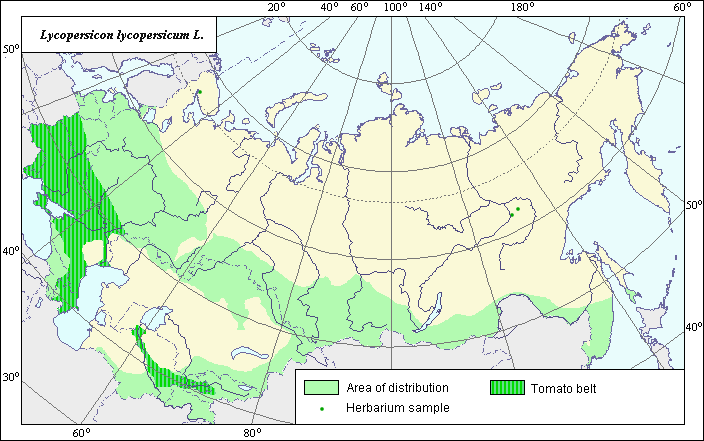 Object description Download GIS-layers
Author:
N.V. TerekhinaDate of creation:
30.09.2004.Scale:
1:20,000,000.Accuracy of map:
The minimal territorial unit consists of regional (oblast) arable territories, which were selected using the arable map and generalized to the scale of 1:20,000,000.Projection:
"Alber.s Equal Area Conic for Russia", 9, 1001, 7, 100, 0, 44, 68, 0, 0.Basic contents:
Map is a vector file consisting of polygons and points. Points represent recorded locations of the species; polygons represent area of possible distribution of the species.Accuracy of classifier:
Polygons are based on literature sources, political boundaries and ecological descriptions. Point data were obtained from literature sources.Method of map production:
Historical agricultural statistics were reviewed at the regional level. The former Soviet Union has 16 regions. The boundaries from the 1:4,000,000 map of arable lands were used to further refine crop distribution (Koroljeva et al., 2003).Reference citations:
Alpat'ev A.V. 1981. Tomatoes. Moscow: Kolos. 304 p.Brezhnev, D.D., ed. 1958. Cultural flora of the USSR. V. 20. Vegetable nightshade family. Moscow-Leningrad: Sel.hozgiz. 530 p.
Koroljeva I.E., Vilchevskaya E.V., Ruhovich D.I. 2003. Digital Arable Land Map. Laboratory of Soil Information of the Dokuchaev Soil Institute, Moscow, Russia [Based on: Yanvareva L.F. (ed.), Martynjuk K.N., Kisileva N.M. 1989. Map of Land Use, Faculty of Geography, Moscow State University, Moscow, Russia.].
State List of Selection Achievements, Admitted to Use. 2004. Moscow. 234 p.
Tokarev V.V., ed. 1986. Tomato, pepper, aubergine. Novosibirsk: Knizhnoe izdatel.stvo. 126 p.
Vehov V.N., Gubanov I.A., Lebedeva G.F. 1978. Cultural plants of the USSR. Moscow: Mysl.. 336 p.
Right and copyright:
Copyright on this map and its description belongs to its authors.© N.V. Terekhina
Photo N.V. Terekhina