
Crops
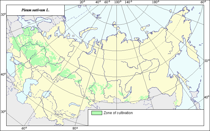
Garden pea cultivation area .
 Object description Download GIS-layers
Author:
Rukhovich D.I., Koroleva I.E., Vilchevskaya E.V.Compilation date:
10.07.2003.Scale:
1:20,000,000.Precision:
The maps of the districts of the Russian Federation and the maps of the regions of the former republics of the Soviet Union were compiled on the scale of 1:20,000,000.Projection:
.Albers equal-area projection for the USSR., 9, 1001, 7, 100, 0, 44, 68, 0, 0.Main content:
Vector map. Polygons show cultivation areas.Content's precision:
The maps contain generalized information about cultured plant's distribution drawn from published sources, taking into consideration the map of cultivated lands of the USSR.Map compilation procedure:
The cultivation areas' map was compiled using a combination of maps of the districts of the Russian Federation, maps of the regions of the former republics of the Soviet Union, the map of natural and agricultural zoning, and the map of cultivated lands. The plants' cultivation area database, comprised of 20 fields, was compiled using district and regional maps. Cultured plants' distribution layer, in accordance with the administrative division, was determined for each field, whereupon non-arable lands were excluded from each layer. The map of the arable lands of the former USSR was created following a reduction of the 1:4,000 000 map of cultivated lands to the scale of 1:20,000 000, taking into account areas where 10% or more of land is tilled. Cultured plants' distribution takes into account only those areas where these plants occupy 3 to 5% or more of the tilled land's area.Data sources:
Central directorate of land surveying and cartography of the Ministry of geology and protection of the earth's interior of the USSR. 1960. Agricultural Atlas of the USSR Moscow, 40 printer's sheets.Central directorate of land surveying and cartography of the Council of Ministers of the USSR. 1969. Atlas of the USSR. 2nd edition. Moscow, 26 printer's sheets.
Gurenev M.N., ed. 1981. Fundamentals of Agriculture. Moscow: "Kolos". 495 p.
Kashtanov A.N., ed. 1983. Natural and Agricultural Zoning and Utilization of Lands Available in the USSR. Moscow: "Kolos", p. 336.
Russian state committee for standardization. 2001. Russian Yearbook of Statistics: Statistic Collection. Vol. 1. Moscow, 679 p.
State Agricultural and Industrial Committee of the Russian Soviet Federative Socialist Republic, All-Union V.I. Lenin Academy of Agricultural Sciences, V.V. Dokuchayev Research Institute of Soil. 1986. Environmental and Economic Conditions of Agricultural Production in the Russian Soviet Federative Socialist Republic. In 3 parts. Moscow.
State committee for standardization of the USSR. 1988. Agriculture of the USSR: Annual of Statistics. Moscow: "Finances and Statistics". 535 p.
State committee for standardization of the USSR. 1991. National Economy of the USSR in 1990 Statistical Yearbook. Moscow: "Finances and Statistics", 752 p.
State Research Institute of Land Resources. 1990. Land resources of the USSR. 4.1. Natural and agricultural zoning of the regions, territories, autonomous republics and republics of the USSR. Moscow.
Utilization of the Soils in the South of the Taiga Zone: Specific Features. 1988. Recommendations for Procedures and Reference Materials of All-Union V.I. Lenin Academy of Agricultural Sciences, V.V. Dokuchayev Research Institute of Soil. Moscow, 51p.
Utilization of the Soils of the Steppe and Dry Steppe Zones: Specific Features. 1988-89. Recommendations for Procedures and Reference Materials of All-Union V.I. Lenin Academy of Agricultural Sciences, V.V. Dokuchayev Research Institute of Soil. Moscow, 68 p.
Yearbook of the Greater Soviet Encyclopaedia 1989, # 33. 1989. Moscow: "Sovyetskaya Entsyklopediya", 591 p.
Rights and copyrights:
All rights to the map are reserved by Rukhovich D.I., Koroleva I.E., Vilchevskaya E.V.Description: Gashkova I.V.
Photo E.V.Kirillova