
Crops
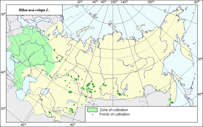
The distribution area of European gooseberry (Ribes uva-crispa L.) .
 Object description Download GIS-layers
Authors:
A.Ju. Doronina, N.V. TerekhinaGIS-experts: N.V. Terekhina, N.M. Kalibernova
Date of creation:
27.03.2005Scale:
1:20,000,000.Accuracy of map:
Map was created using a map of gardens of the former USSR to the scale of 1: 20,000,000.The projection:
"Alber's Equal Area Conic for Russia", 9, 1001, 7, 100, 0, 44, 68, 0, 0Basic contents:
Map is a vector file consisting of polygons and points. Points represent recorded locations of the species; polygons represent area of possible distribution of the species.Accuracy of classifier:
Polygons are based on literature sources, political boundaries and ecological descriptions. Point data were obtained from literature sources and herbarium specimens. Polygons are based on literature sources, herbarium samples, and field surveys by the authors.Method of map production:
Historical agricultural statistics were reviewed at the regional level. The Former Soviet Union had 16 regions. The boundaries shown on the 1:4000000 map of arable lands (Koroljeva et al., 2003) were used to further refine areas of crop distribution. The area map was created using Tulupnikov (1960) and the State list (1994, 2004). The polygon area covers the temperate zone of the European region of the former USSR (regions of the central-nechernozem zone, the central-chernozem zone and northwestern regions) according to Bahteev (1970), Vehov (1978), and Vitkovskij (2003). Species is also cultivated in Kazakhstan (Frolova, 1956), in the Far East (Koropachinskij, 2002), in Middle Asia, in southern Siberia and in the Archangelsk region (Sokolov, 1954); these areas were marked by points.Reference citations:
Bahteev F.H. 1970. The major fruit plants. Moscow: Prosvezhenie. 351 p.Frolova A.A. 1956. The questions of biology and agrotechnics of the gooseberry in the conditions of foothills zone of Zailiisky Alatau. V. 3. The works of Alma-Ata Botanical garden of Academy science Kazakh SSR. 81-91 p.
Geideman T.S. 1975. Manual of the highest plants of Moldavskaja SSR. Tashkent: Shtiinza. 576 p.
Klokov, M.V. & O.D. Visulina, eds. 1953. Flora URSR. V. 5. Kiev: Vidavniztvo akademii nauk URSR. 528 p.
Koroljeva IE, Vilchevskaya EV, Ruhovich DI. 2003. Digital Arable Land Map. Laboratory of Soil Information of the Dokuchaev Soil Institute, Moscow, Russia [Based on: Yanvareva LF. (ed.), Martynjuk K.N., Kisileva N.M. 1989. Map of Land Use, Faculty of Geography, Moscow State University, Moscow, Russia.].
Kropachinsky I.Ju., Vstovskaja T.N. 2002. Tree of Asian part of Russia. Novosibirsk: izdatelstvo SO RAN. 707 p.
Sokolov S.J., ed. 1954. Trees and shrubs of USSR. V. 3. Moscow-Leningrad: Nauka. 784-800 p.
State List of Selection Achievements, Admitted to Use. Moscow, 1994.
State List of Selection Achievements, Admitted to Use. Moscow, 2004.
Tulupnikov A.I., ed. 1960. Agricultural Atlas of USSR. Moscow.
Vehov V.N., Gubanov I.A., Lebedeva G.F. 1978. Cultural plants of the USSR. Moscow: Mysl.. 336 p.
Vitkovsky V.L. 2003. Fruit plants of the world. St. Petersburg, Moscow, Krasnodar: Lan. 592 p.
Right and copyright:
Copyright on map and its description belongs to its authors.© N.V. Terekhina, N.M. Kalibernova, A.Ju. Doronina
Photo N.V. Terekhina