
Crops
The area of Sorgho (Sorghum saccharatum Pers.)
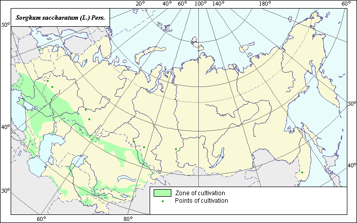 Object description Download GIS-layers
Autor:
The expert and GIS-expert: N.V. TerekhinaDate of creation:
27.02.2005Scale:
1:20,000,000Accuracy of map:
Map was created using a map of the gardens of the former USSR with the scale of 1: 20,000,000.The projection:
"Alber's Equal Area Conic for Russia", 9, 1001, 7, 100, 0, 44, 68, 0, 0.Basic contents:
Map is a vector file consisting of polygons and points. Points represent recorded locations of the species; polygons represent area of possible distribution of the species.Accuracy of classifier:
Polygons are based on literature sources, political boundaries and ecological descriptions. Point data were obtained from literature sources and herbarium specimens. Polygons are based on literature sources, herbarium samples, and field surveys by the authors.Method of map production:
GIS specialists at the Moscow Soil Institute carried out the mapping. Working with agronomists, historical agricultural statistics were reviewed at the district (rajon) level to determine whether or not the crop was cultivated. Crop distribution was based on crop production at the rajon-level, which was further refined using the boundaries shown on the 1:4000000 map of arable lands (Koroljeva et al., 2003). The area map was created using Tulupnikov (1960) and State list (1994, 2004). The polygon area covers Middle Asia, Transcaucasica, the Northern Caucasus, Southern Ukraine, the Lower Volga and Moldova, according to the following sources: Tulupnikov (1960), Shorin (1973), 1976, 1986), Vehov (1978), Golubeva (1983), Shepel' (1989), and Davletshin (1999). Also, Vasilevskij (1990) and Bobrenko (1997) reference the successful cultivation of the species in Western Siberia and well as in Kaliningrad, Briansk, Tatarstan, Bashkiria, Krasnojarsk, Novosibirsk and the Far East; these areas are represented by points. Also instrumental in map development was a consultation with the General Specialist in the Grain Cultures Department of VIR, B.N. Malinovskij, PhD.Reference citations:
Bobrenko I.A. 1997. Diagnostic of mineral nutrition, size and quality of yield of Sorgho on chernozem of Western Siberia. Omsk.Catalogue of zoning grades of agriculture species (without potato, vegetables and melon cultures). Moscow, 1965.
Davletshin T.Z. 1999. Culture sorghum in Tatarstan. Kazan.
Golubeva G.S. 1983. Achivments of sorgho growing technologies. Moscow.
Koroljeva IE, Vilchevskaya EV, Ruhovich DI. 2003. Digital Arable Land Map. Laboratory of Soil Information of the Dokuchaev Soil Institute, Moscow, Russia [Based on: Yanvareva LF. (ed.), Martynjuk KN., Kisileva NM. 1989. Map of Land Use, Faculty of Geography, Moscow State University, Moscow, Russia.].
Shepel' N.A. 1989. Sorgho - intensive culture. Simferopol. 187 p.
Shorin P.M. 1976. Sorgho. Moscow.
Shorin P.M. 1986. Technology of cultivation and use of Sorgho. Moscow. 87 p.
Shorin P.M., Malinovskij B.N., Miroshnitchenko V.F. 1973. Sorgho is a valuable fodder culture. Moscow.
State List of Selection Achievements, Admitted to Use. Moscow, 1994.
State List of Selection Achievements, Admitted to Use. Moscow, 2004.
Tulupnikov A.I., ed. 1960. Agricultural Atlas of USSR. Moscow.
Vasilevsky V.D. 1990. Biological features and methods of Sorgho growing in southern partially wooded steppe. Omsk.
Vehov V.N., Gubanov I.A., Lebedeva G.F. 1978. Cultural plants of the USSR. Moscow.
Right and copyright:
Copyright on the map and its description belongs to its author.© Terekhina N.V.
Photo copyright Terekhina N.V.