
Diseases
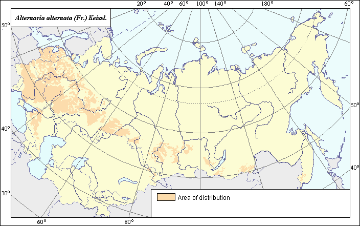
Distribution and severity zones of Alternaria alternata (Fr.) Keissl.
 Object description Download GIS-layers
Authors:
Specialist-biologist - Kungurtseva O.V.,GIS-specialist - Saulich M.I.
Date of creation:
18.01.2005.Scale.
1: 20 000 000.Accuracy of map:
Map was created from a map of scale 1: 33 000 000.Projection:
"Alber's Equal Area Conic for the USSR", 9, 1001, 7, 100, 0, 44, 68, 0, 0.Basic contents:
Vector map. Area of species distribution and zones of disease severity are shown by polygons.Accuracy of classifier:
The distribution area of the fungus coincides with the area of pea cultivation.Method of map production:
Scientists were given maps with boundaries of Oblasts and arable lands. After reviewing historic literature, species distribution was hand drawn on maps. If data were on the Oblast-level, distribution is on the Oblast level. In some cases, Oblast.s are further refined by boundaries of the Arable Land Map (Koroljeva et al., 2003). Hand drawn maps were scanned, georeferenced and vectorized. The map of the distribution and severity zones of the fungus was determined according to the materials published by the following sources: Pidoplichko (1977), Bagaeva (1964), Dobrovolpskaya (1973), Khaleeva (1965). According to this data the area of the disease occupies all areas of industrial cultivation of peas (Koroljeva et al., 2003). Pskov, Novgorod, and Leningrad Regions in Northwest of Russia, and also central and some southern regions of Ukraine were added.Reference citations:
Bagaeva E.I., Vinogradova N.I. 1964. Diseases of leguminous plants in Forest-steppe zone of Omsk region. Proceedings of Omsk. V. 54. 45-56 p. (In Russian)Dobrovolpskaya E.A. 1973. Diseases of seeds of peas and their control in conditions of southern steppe of Ukraine. PhD Thesis. Odessa. 22 p. (In Russian)
Khaleeva Z.N. 1965. Mycoflora of pea seeds. Brief results of scientific researches on plant protection in the Baltic zone of the USSR. V. 6 (1963). Riga. Zvaintse. 89-91 p. (In Russian)
Koroljeva IE, Vilchevskaya EV, Ruhovich DI. 2003. Digital Arable Land Map. Laboratory of Soil Information of the Dokuchaev Soil Institute, Moscow, Russia [Based on: Yanvareva LF. (ed.), Martynjuk KN., Kisileva NM. 1989. Map of Land Use, Faculty of Geography, Moscow State University, Moscow, Russia.].
Pidoplichko N.M. 1977. Fungal parasites of cultural plants. Guide, vol. 2. Kiev: Naukova Dumka. 299 p. (In Russian)