
Diseases
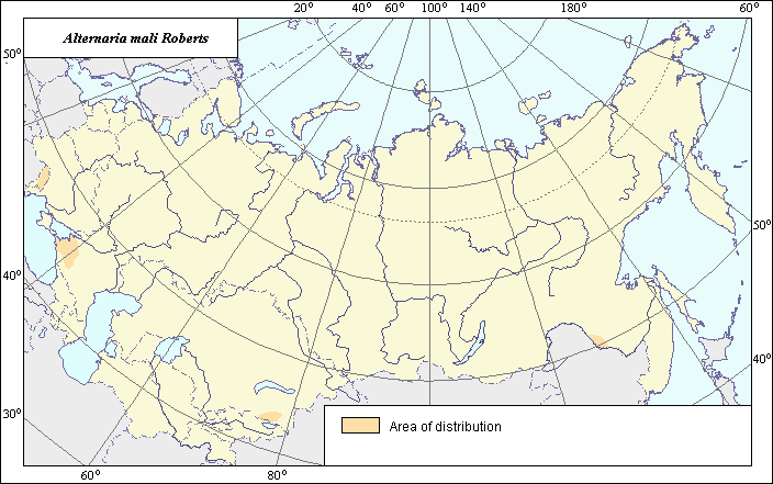
Distribution of Alternaria Blotch of Apple (Alternaria mali Roberts)
 Object description Download GIS-layers
Authors:
Specialist-biologist - I.V. Bilder,GIS-specialist - M.I. Saulich.
Date of creation:
12.08.04Scale:
1:20 000 000.Accuracy of map:
Map was created based on materials of map of natural scale 1:33 000 000Projection:
"Equal Albers for the USSR ", 9, 1001, 7, 100, 0, 44, 68, 0, 0Basic contents:
Vector map. Area of species distribution and zones of disease severity are shown by polygons.Accuracy of classifier:
Distribution was determined based on the regions where Alternaria Blotch is registered on apple according to published scientific materials.Method of map production:
Scientists were given maps with boundaries of Oblasts and arable lands. After reviewing historic literature, species distribution was hand drawn on maps. The distribution of the disease within the limits of the former USSR coincides with the area of apple cultivation. Alternaria Blotch of apple was registered in Krasnodar Territory, the Far East, Alma-Ata area of Kazakhstan, and Moldova (Gagkaeva & Levitin, 1999, 2000). If data were on the Oblast-level, distribution is on the Oblast level. In some cases, Oblast.s are further refined by boundaries of the Arable Land Map (Koroljeva et al., 2003). Hand drawn maps were scanned, georeferenced and vectorized.Reference citations:
Ablakatova A.A. 1965. Mycoflora and the basic fungal diseases of fruit plants of the south of the Far East. Moscow-Leningrad: Nauka. 146 p. (In Russian)Gagkaeva T.Yu., Livitin M.M. 1999. Alternaria Blotch - new dangerous disease in the south of Russia. Agro XXI. N. 10. Moscow: Agrorus. 12-13 p. (In Russian)
Gagkaeva T.Yu., Levitin M.M. 2000. Identification of the pathogen causing leaf spots on apple trees in Krasnodar orchards. Mycology and Phytopathology; St. Petersburg: Nauka; 34(3): 58-61. (In Russian)
Koroljeva IE, Vilchevskaya EV, Ruhovich DI. 2003. Digital Arable Land Map. Laboratory of Soil Information of the Dokuchaev Soil Institute, Moscow, Russia [Based on: Yanvareva LF. (ed.), Martynjuk KN., Kisileva NM. 1989. Map of Land Use, Faculty of Geography, Moscow State University, Moscow, Russia.].