
Diseases
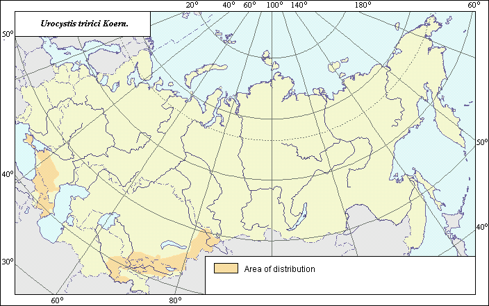
Distribution of Flag Smut on wheat Urocystis tritici Koern.
 Object description Download GIS-layers
Authors:
Specialist-biologist - T.Yu. Gagkaeva, GIS-specialist - M.I. Saulich.Date of creation:
08.08.2003Scale:
1:20 000 000.Accuracy of map:
Map was created based on materials of maps of natural scale 1:40 000 000Projection:
"Alber's Equal Area Conic for the USSR", 9, 1001, 1, 100, 0, 44, 68, 0, 0Basic contents:
Vector map. Area of species distribution and zones of disease severity are shown by polygons.Accuracy of classifier:
Within the limits of the former USSR distribution of the disease is represented by a single zone. All regions where Flag Smut is found are mapped according to scientific publications. The harmfulness of disease is related to a decrease of plant growth rate, a lesser number and smaller size of leaves. Diseased plants produce yield by 5 times less, compared to healthy plants. As a rule, an average percent of attacked plants corresponds to percent of yield losses.Method of map production:
Scientists were given maps with boundaries of Oblasts and arable lands. After reviewing historic literature, species distribution was hand drawn on maps. If data were on the Oblast-level, distribution is on the Oblast level. In some cases, Oblast.s are further refined by boundaries of the Arable Land Map (Koroljeva et al., 2003). Hand drawn maps were scanned, georeferenced and vectorized.Reference citations:
Koroljeva IE, Vilchevskaya EV, Ruhovich DI. 2003. Digital Arable Land Map. Laboratory of Soil Information of the Dokuchaev Soil Institute, Moscow, Russia [Based on: Yanvareva LF. (ed.), Martynjuk KN., Kisileva NM. 1989. Map of Land Use, Faculty of Geography, Moscow State University, Moscow, Russia.].Peresipkin V.F. 1969. Flag smut. In: Agricultural Phytopathology. Moscow. 10-11 p. (In Russian)