
Pests
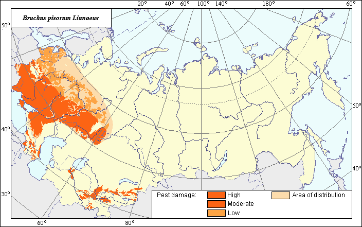
Distribution area and damage zones of Bruchus pisorum Linnaeus
 Object description Download GIS-layers
Authors:
Specialist biologist M.N. BerimGIS-specialist M.I. Saulich
Date of creation:
27.12.2004.Scale:
1:20,000,000.Accuracy of map:
Map was created using a map to the natural scale 1:33,000,000.Projection:
"Alber's Equal Area Conic", 9, 1001, 7, 100, 0, 44, 68, 0, 0.Basic contents:
Vector map consists of 4 thematic layers. Zones of distribution and damage are shown by polygons.Accuracy of the classifier:
The insect distribution area was divided into zones of high, moderate and low damage using published materials (Vasil'ev, 1939, 1941; Rogulev, 1988; and others). The zone of high damage includes regions that are characterized by periodic damage to pea grains reaching 70-90% (germination rate decreases to 70-80%); the zone of moderate damage is characterized by damage to pea grains reaching 40-70% (germination rate decreases to 35-70%); the zone of low damage is characterized by damage to pea grains reaching 40% (germination rate decreases to 35%) (Rogulev, 1988).Mapping procedure:
The damage zones of Bruchus pisorum Linnaeus were marked on a blank map following an analysis of the published materials. The materials of VIZR expeditions were also used. The boundaries of the zones of harmfulness were determined using criteria published by Z.V. Ivanova (1959, 1960); E.Rostovtseva (1963); O.F. Fedosimov (1970); A.F.Rogulev (1988); Yu. A. Malakhanov (1989); and G.A. Posylaeva, Yu.A. Malakhanov (1989). The northern border was determined according to published materials (Vasil'ev, 1939, 1941) and the data of expeditions. The results of the analysis of host (pea) spreading from the atlas of the USSR vegetation were also used, taking into account temperature preferences of this insect (the insect is cold-resistant). The vector map of distribution of peas within the territory of the former Soviet Union and the map of arable lands were also used to correct the boundaries of the damage zones (Koroleva et al., 2003). The map was scanned; its registration and vectorization were made using GIS-technology.Sources of data:
Fedosimov O.F. 1970. To biology of pea weevil in South-East of Kazakhstan. Proceedings of 2nd scientific conference of young specialists and post-graduate students. Alma-Ata. P. 42-3 (in Russian).Ivanova Z.V. 1959. Pea weevil. Moscow: Publishing house of agricultural literature. 47 p. (in Russian).
Ivanova Z.V. 1960. Pea weevil and its control. In: Osipova E.N., ed. Leguminous cultures. Moscow: Publishing house of agricultural literature. P. 311-9 (in Russian).
Malakhanov Yu.A. 1989. Damaging of pea plants by pea weevil in dependence on vegetation conditions. In: Novozhilov K.V., ed. Bulletin of VIZR, N 74, Leningrad. P. 60-7 (in Russian).
Posylaeva G.A., Malakhanov Yu. A. 1989. Pea weevil in Ukraine. Zashchita rastenii 3: 18-19 (in Russian).
Rogulev A.F. 1988. Zones of high harming activity and information background for forecasting pea weevil development. In: Shurovenkov Yu.B., ed. Proceedings of All-Russian research institute of plant protection, Voronezh: VIZR. P. 7-13 (in Russian).
Rostovtseva E.G. 1963. Pea weevil and its control. Zernobobovye kul'tury 2: 32-3 (in Russian).
Vasil'ev I.V. 1939. Origin and world distribution of pea weevil (Bruchus pisorum L.). Vestnik zashchity rastenii 1. P.44-5 (in Russian).
Vasil'ev I.V. 1941. Pea weevil (Bruchus pisorum L.). Vestnik zashchity rastenii 1. P.27-36 (in Russian).