
Pests
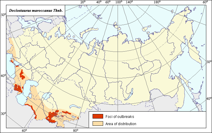
The area and zone of mass reproduction of the Moroccan Locust - Dociostaurus maroccanus (Thnb.)
 Object description Download GIS-layers
Authors:
Specialist-biologist I.Ya. Grichanov, GIS-specialist - M.I. Saulich.Date of creation:
26.05.2002.Scale:
1:20.000.000.Accuracy of map:
Map was created based on materials of maps of natural scale 1: 12 000 000 000, 1:40 000 000 and 1: 55 000 000.Projection:
"Alber.s Equal Area Conic for the USSR", 9, 1001, 7, 100, 0, 44, 68, 0, 0.Basic contents:
Vector map of two thematic layers. Area of species distribution is shown by polygons. Zones of recorded mass reproduction and outbreak are shown by polygons.Accuracy of classifier:
Within the species distribution area, the zone with the niduses of the Moroccan Locust mass reproduction is separated. The border of the zone of strong harm (not shown) varies, depending on pest migrations, population density, extent of area cultivated and weather conditions, spreading as far as 250 km from niduses of the mass reproduction.Method of map production:
Scientists were given maps with boundaries of Oblasts and arable lands. After reviewing historic literature, species distribution was hand drawn on maps. If data were on the Oblast-level, distribution is on the Oblast level. In some cases, Oblast.s are further refined by boundaries of the Arable Land Map (Koroljeva et al., 2003). Hand drawn maps were scanned, georeferenced and vectorized. The map of Tsyplenkov (1970) was used as a base map and was adjusted according to the following sources: Polyakov (1975) and Lachininskii et al. (2002)-concerning Almaty Province at the Kazakhstan-China border, Kherson Region and Kuban river valley.Reference citations:
Bei-Bienko G.Ya. 1932. A manual of locust survey. Leningrad: Upravlenie Sluzhby ucheta Gos. OBV Narkozema SSSR. 159 pp.Bei-Bienko G.Ya., Mishchenko L.L. 1951. Locusts of the fauna of the USSR and adjacent countries. In: Keys on the USSR fauna, N. 38, parts I & II. Moscow & Leningrad: AN SSSR. 668 pp.
Koroljeva IE, Vilchevskaya EV, Ruhovich DI. 2003. Digital Arable Land Map. Laboratory of Soil Information of the Dokuchaev Soil Institute, Moscow, Russia [Based on: Yanvareva LF. (ed.), Martynjuk KN., Kisileva NM. 1989. Map of Land Use, Faculty of Geography, Moscow State University, Moscow, Russia.].
Lachininskii A.V., Sergeev M.G., Chil.debaev M.K., Chernyakhovsky M.E., Lockwood J.A., Gapparov F.A. 2002. Locusts of Kazakhstan, Central Asia and adjacent territories. Larami: Association for Applied Akridology International, University of Wyoming. 387 pp.
Mishchenko L.L. 1952. Locusts (Catantopinae). Leningrad: AN SSSR. Fauna of the USSR. Orthopterous insects, 4(2): 610. (In Russian)
Polyakov I.Ya., ed. 1975. Distribution of main pests of agricultural crops in the USSR and efficiency of their control (Methodical recommendations). Leningrad: VASKHNIL, VIZR. 66 pp.
Sergeev M.G. 1986. Regularities in distribution of orthopterous insects of Northern Asia. Novosibirsk: Nauka. 238 pp.
Uvarov B.P. 1977. Grasshopers and Locusts. A Handbook of General Acridology. London: COPR. V. 2: 624 pp.
Right and copyright:
All rights reserved.Copyright 2003 © I.Ya. Grichanov & M.I. Saulich (vector map, description) and I.Ya. Grichanov (photo).