
Pests
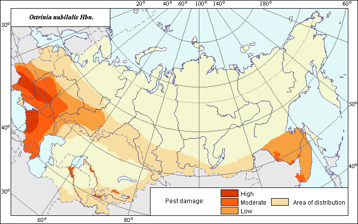
Area of the European corn borer (Ostrinia nubilalis )
 Object description Download GIS-layers
Authors:
specialist-biologist A.N. Frolov, GIS-specialist M.I. Saulich.Date of creation:
26.02.2002.Scale:
1:20.000.000.Accuracy of map:
Map was created based on materials of maps of natural scale 1:12.000.000-1:80.000.000.Projection:
"Alber.s Equal Area Conic", 9, 1001, 7, 100, 0, 44, 68, 0, 0.Basic contents:
Vector map. Area of species distribution is shown by polygons. Zone of low pest damage is shown by polygons.Accuracy of classifier:
Insect area is divided into zones of distribution and three zones of harmfulness. Area of high harmfulness is characterized by 20-100% infested plants. Area of moderate harmfulness is characterized by 10-20% infested plants. The area of weak harmfulness is characterized by less than 10% infested plants.Method of map production:
Scientists were given maps with boundaries of Oblasts and arable lands. After reviewing historic literature, species distribution was hand drawn on maps. If data were on the Oblast-level, distribution is on the Oblast level. In some cases, Oblast.s are further refined by boundaries of the Arable Land Map (Koroljeva et al., 2003). Hand drawn maps were scanned, georeferenced and vectorized. The area of distribution was determined using the map of Kozhanchikov (1938) as a base and adjusted in the Far East and Central Asia according to the following sources: All Russian Institute of Plant Protection (1975), Frolov (1994), Ishikawa et al. (1999). The various borders of the areas of harmfulness were determined according to the All Russian Institute of Plant Protection (1975) and adjusted for the Ukraine according to Bakhmout (2002). Other sources used to adjust the borders of the zones of harmfulness included: Frolov (1994), Ishikawa et al. (1999) and political maps.Reference citations:
All Russian Institute of Plant Protection. 1975. Methodical guideline: Distribution of the main pests of agricultural crops in the USSR and efficiency of their control measures. Leningrad: VASKHNIL, VIZR. 66 pp.Bakhmout O.O. 2002. Resistance of hybrids and varieties of maize to the European corn borer and long-term forecast of its number in the forest-steppe region of Ukraine. PhD Thesis in agricultural science, Kiev.
Frolov A.N. 1994. Geographic variation of population structure in Ostrinia spp. living on dicotyledonous host plants and factors determining variation. Entomological Review, 73(7): 134-148.
Ishikawa Y., Takanashi T., Kim Choong-gon, Hoshizaki S., Tatsuki S., Huang Yongping. 1999. Ostrinia spp. in Japan: their host plants and sex pheromones. Entomol. Exp Et Appl., 91: 237-244.
Koroljeva IE, Vilchevskaya EV, Ruhovich DI. 2003. Digital Arable Land Map. Laboratory of Soil Information of the Dokuchaev Soil Institute, Moscow, Russia [Based on: Yanvareva LF. (ed.), Martynjuk KN., Kisileva NM. 1989. Map of Land Use, Faculty of Geography, Moscow State University, Moscow, Russia.].
Kozhanchikov I.V. 1938. Geographical distribution and physiological characters of Pyrausta nubilalis Hbn. Zoological Journal, 17(2): 246-259. (In Russian)
Mutuura A., Munroe E. 1970. Taxonomy and distribution of the European corn borer and allied species: genus Ostrinia (Lepidoptera: Pyralidae). Entomol. Soc. Canada Mem., 71: 112.