
Pests
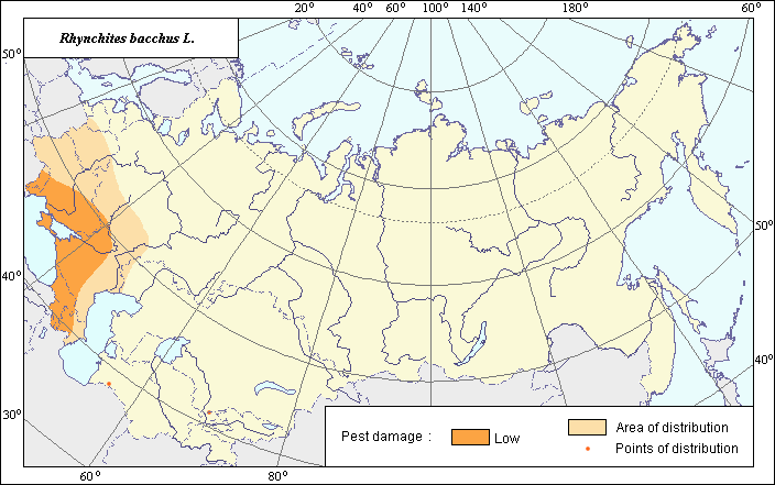
Area and pest damage zones of Rhynchites bacchus L.
 Object description Download GIS-layers
Authors:
Object specialist - G.E. David'yan, GIS-specialist - M.I. Saulich.Date of creation:
20.12.2003.Scale:
1:20 000 000.Accuracy of map:
Created using maps with a scale of 1:40 000 000 and on information taken from the literature, and by an analysis of the collections of the Zoological Institute, the Russian Academy of Sciences.Projection:
.Alber.s Equal Conica for the USSR., 9, 1001, 7, 100, 0, 44, 68, 0, 0.Basic content:
Vector map, consisting of 2 thematic layers. Area of distribution and zones of pest damage are shown by polygons.Accuracy of classifier:
In the beginning of the 20th century, the significance of this pest was greater. 30-40 pairs of beetles per one plum tree were capable of destroying the entire harvest (Grossheim, 1928). However, now within the area of distribution, there is only a zone of low pest damage, not defined, since during the last 20-30 years, the pest population has been depressed following the application of effective pesticides (Savkoskii, 1976).Method of map production:
Scientists were given maps with boundaries of Oblasts and arable lands. After reviewing historic literature, species distribution was hand drawn on maps. If data were on the Oblast-level, distribution is on the Oblast level. In some cases, Oblast.s are further refined by boundaries of the Arable Land Map (Koroljeva et al., 2003). Hand drawn maps were scanned, georeferenced and vectorized. Data from open publications were used to determine area and pest damage zones of the species. The map of species area is based on an analysis of the collection of the Zoological Institute. The localities of the species were marked on a blank geographical map (Bobrinskii et al., 1969). Corrections and additions to the northern border of the area were made based on Grossheim (1928). Borders of the low pest damage zone are based on Grossheim (1928) and Dobrovol'skii (1959) and comprise the territory of Moldavia, Ukraine, the South of the European part of Russia including the North Caucasus, and foothills of Transcaucasia.Reference citations:
Bobrinskii N.A., Kuznetsov B.A., Kuzyakin A.P. 1965. Keys to Mammals of the USSR. Kuzyakin A.P., editor. Moscow: Prosveshchenie. 382 p. (In Russian)Dobrovol'skii B.V. 1959. Distribution of the harmful insects. Moscow: Sovetskaya Nauka. 215 pp. (In Russian).
Grossgeim N.A. 1928. Rhynchites bacchus L. Proceedings of horticultural and truck farming station in Mleev. Mleev: NKZS-UkrSSR. N. 10: 143. (In Russian)
Koroljeva IE, Vilchevskaya EV, Ruhovich DI. 2003. Digital Arable Land Map. Laboratory of Soil Information of the Dokuchaev Soil Institute, Moscow, Russia [Based on: Yanvareva LF. (ed.), Martynjuk KN., Kisileva NM. 1989. Map of Land Use, Faculty of Geography, Moscow State University, Moscow, Russia.].
Savkovskii P.P. 1976. Atlas of the horticultural crops pests. Kiev: Izd-vo Urozhai. 207 pp.
Ter-Minasyan M.E. 1950. Roller-weevils (Attelabidae). Fauna USSR. Insecta-Coleoptera. Moscow & Leningrad: AN SSSR. V. 27(2): 231. (In Russian)
Right and copyright:
All rights reserved.Copyright 2003 © G.E. David'yan & M.I. Saulich (vector map, description) and G.E. David'yan (picture).