
Pests
Area of distribution and harmfulness of Ukrainian blind mole-rat (Spalax microphtalamus Guldenstaedt.)
 Object description Download GIS-layers
Authors:
Object specialist - F.A. Karlik, GIS-specialist - M.I. Saulich.Data of creation:
11.12.2003.Scale:
1:20 000 000.Accuracy of map:
Map was created based on materials of maps of natural scale 1:12 000 000 - 1:40 000 000.Projection:
"Alber's Equal Area Conic for the USSR", 9, 1001, 7, 100, 0, 44, 68, 0, 0.Basic contents:
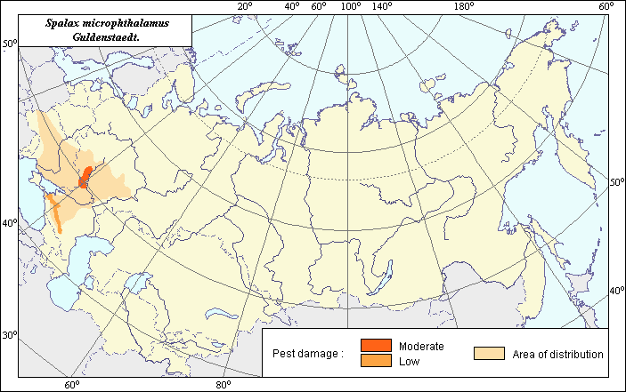
Vector map. Area of species distribution is shown by polygons. Zones of recorded mass outbreak are shown by polygons.Accuracy of classifier:
Within the area of distribution two zones of harm, moderate and weak, are established according to the level of colonization of arable lands. In the zone of moderate harm blind mole-rats constantly inhabit unplowed plots, pastures and haylands, and they colonize the fields of main agricultural crops. In the zone of weak harm blind mole-rats are only occasionally found in arable lands, and are absent during sowing (Ovchinnikova, 1971).Method of map production:
Scientists were given maps with boundaries of Oblasts and arable lands. After reviewing historic literature, species distribution was hand drawn on maps. If data were on the Oblast-level, distribution is on the Oblast level. In some cases, Oblast.s are further refined by boundaries of the Arable Land Map (Koroljeva et al, 2003). Hand drawn maps were scanned, georeferenced and vectorized. Two published maps that demonstrate an up-to-date distribution of the blind mole-rat in Ukraine, Moldova and Russia were scanned. For the most part the map of Flint et al. (1970) was used to determine the boundaries of the distribution area. In the north and south the distribution of the species was adjusted according to the map of Pavlinov et al. (2002). The zone of moderate harm is demonstrated in the right-bank part of the Don River within the Voronezh region. This territory is characterized by strong gully areas of the Central Chernozem region, i.e. to the places which are not suitable for plowing and so are the most favorable for blind mole-rat habitats (Ovchinnikova, 1971). The zone of weak harm is depicted for steppe and forest-steppe zones in sub-mountain parts of the Krasnodar and Stavropol Territories.Reference citations:
Flint V.E., Chugunov Yu.D., Smirin V.M. 1970. Mammals of the USSR. Moscow: Mysl. 437 p.Koroljeva IE, Vilchevskaya EV, Ruhovich DI. 2003. Digital Arable Land Map. Laboratory of Soil Information of the Dokuchaev Soil Institute, Moscow, Russia [Based on: Yanvareva LF. (ed.), Martynjuk KN., Kisileva NM. 1989. Map of Land Use, Faculty of Geography, Moscow State University, Moscow, Russia.].
Ovchinnikova S.L. 1971. The distribution of blind mole-rat (Spalax microphtalamus Guldenstaedt.) in south-east part of Central Chernozem region. Transactions of Voronezh State University. Voronezh. V. 93: 80-83.
Pavlinov I.Ya., Kruskop S.V., Varshavskii A.A., Borisenko A.V. 2002. Land animals of Russia. In: Dunaev E.A., Mikhailov K.G., editors. Manual-Identification Book. Moscow: KMK. 298 p.
Puzachenko A.Yu. 2003. Blind mole-rat. Centre of conservation of wild nature: Rodents of the former USSR. Moscow: www.biodiversity.ru .
Topachevskii V.A. 1969. Spalacidae. In: Byckhovskii B.E., editor. Series Fauna of the USSR, Mammalia, V. 3, Issue 3. Leningrad: Nauka. 248 p.