
Pests
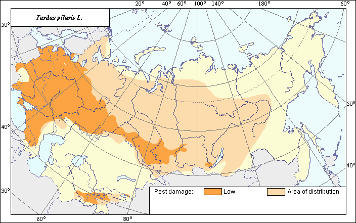
Area of distribution and damage of Turdus pilaris L.
 Object description Download GIS-layers
Authors:
Biologist specialist - F.A.Karlik,GIS-specialist - M.I.Saulich.
Date of creation:
19.10.2006.Scale:
1:20 000 000.Accuracy of the map:
It is created on materials of maps of natural scale 1:33 000 000 - 1:80 000 000.Projection:
"Alber's Equal Area Conic for the USSR", 9, 1001, 7, 100, 0, 44, 68, 0, 0.Basic content:
Vector map consisting of 2 thematic layers, where area of distribution and zone of damage are shown by polygons.Accuracy of the classifier:
Within the area of T. pilaris, the zone of damage is marked out where harming activity of this species regularly reaches economically significant yield losses of cultural fruits and berries; i.e., 3-5%, in some years locally reaching 20% or more.Method of map production:
The area of distribution of T. pilaris within the Former Soviet Union is composed according to the open published maps taken from the books of S.Cramp (1988), U.N.G. von Blotzheim (1988), R.L. Beme & A.A. Kuznetsov (1966), G.P.Dementyev et al. (1968). The final version of the area depicted on the map includes the zones of nesting and wintering of this species. The area established after the above-mentioned literature sources occupies a rather large territory, including Baltic States (Estonia, Latvia, Lithuania), Belarus, Moldova, Ukraine, almost all European part of the Russian Federation, part of Western and Eastern Siberia. The western limit of the area completely coincides with the western frontier of the Former Soviet Union, which corresponds to all literature sources. The northern, eastern and southern parts of the limit of the area are mainly shown by the materials from the publications of U.N.G. von Blotzheim (1988), R.L. Beme & A.A. Kuznetsov (1966). An isolated part of the area in the south of the Central Asia represents the zones of wintering according to S.Cramp (1988). The adjoining desert areas remain uninhabited. The zone of low damage within the area coincides in general with the zone of industrial growing of the main fruit and berry crops. Therefore, the vector maps of the distribution of the main fruit and berry crops from (see corresponding map of the Atlas) have been used for the depicting of the zone of damage.Reference citations:
Beme, R.L. & Kuznetsov, A.A. 1966. Birds of forests and mountains of the USSR (field key). Moscow: Prosveshchenie. 272 p. (in Russian)Blotzheim, von U.N.G., ed. 1988. Handbuch der Vogel Mitteleuropas [Handbook of Mideuropean birds]. Vol. 11/II. Wiesbaden: AULA-Verlag, p. 733-1226.
Cramp, S. & Perrins, C.M., ed. 1988. Handbook of the Birds of Europe, the Middle East and North Africa (The Birds of the Western Palearctic). Vol. 5. Oxford-New York: Oxford University Press.
Dement.ev, G.P., Gladkov, N.A., Sudilovskaya, A.M., Spangenberg, E.P., Beme, L.B., Volganetskii, I.B., Voinstvenskii, M.A., Gorchakovskaya, N.N., Korelov, M.N. & Rustamov, A.K. 1954. Birds of the USSR. V.6. Moscow: Sovetskaya Nauka. 792 p. (in Russian)
Flint, V.E., Beme, R.L., Kostin, Yu.V. & Kuznetsov, A.A. 1968. Birds of the USSR (reference keys of geographer and traveller). Moscow: Mysl. 637 p. (in Russian)
Golovanova, E.N. 1972. About harmfulness of fieldfare. Zashchita rastenii 5: 38 (in Russian)