
Relatives
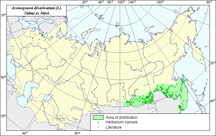
The area of Aconogonon divaricatum (L). Nakai ex Mori. (Spread wide knotweed)
 Object description Download GIS-layers
Authors:
The expert-botanist - T.N. Smekalova, theGIS-expert - R.S. Ushakova.
Date of creation:
25.11.2004Scale:
1:20 000 000.Accuracy of map:
Map was created based on maps having the following scale: 1:20 000 000 - 1:25 000 000 and on data from herbarium specimens.The projection:
"Alber's Equal Area Conic for Russia", 9, 1001, 7, 100, 0, 44, 68, 0, 0Basic contents:
Vector map. Area of species distribution is shown by polygons and actual location occurrence is shown by points.Accuracy of classifier:
Point data were obtained from literature sources and herbarium specimens. Light-colored points are locations referenced in literature sources. Dark-colored points are locations of species that were reported from herbarium samples (V.L. Komarov Botanical Institute, N.I. Vavilov Institute of Plant Industry).Polygons are based on literature sources, herbarium samples, and field surveys by the authors.Method of map production:
Published literature was reviewed, including Atlases, monographs and papers. Occurrence data were obtained from herbarium specimens, floras, monographs and papers. Location and area of distribution of the species was determined according to the following herbarium materials and literature sources: V.L. Komarov Botanical Institute, N.I. Vavilov Institute of Plant Industry, Cherepanov (1995), Malyshev & Peshkova (1992), Kharkevich (1989), Malyshev & Peshkova (1997). The area consists of the basic range of sites of the species in the south of Siberia and in the Far East, and the small island range which includes sites of the species in the northern part of Sakhalin. All sites in the territory of the former USSR represent the northern part of the natural area of the species (Mongolia, the north of China and Japan). The western border of the basic range passes on the east coast of the lake of Baikal and the east border aligns with the coastal line. The southern border coincides with the frontier of the former USSR, and northern was determined by generalization of the numerous factual data of species distribution in the territory of Siberia and the Far East. The points which were not included in the polygon area represent invasive sites of species. Data were then compiled through scanning and geo-referencing to develop a composite vector map. The biologist, together with the GIS specialist, drew a new plant distribution area based on compiled data.Reference citations:
Cherepanov S.K. 1995. Plantae Vasculares Rossicae et Civitatum Collimitanearum (in limics USSR olim)[List of Vascular Plants of Russia]. St. Petersburg: Mir I Semia. 990 pp. (In Russian)Kharkevich S.S., ed. 1989. Vascular plants of the Soviet Far East. V. 4. Leningrad: Nauka. 380 p. (In Russian)
Komarov, V.L., ed. 1936. Flora USSR. V. 5. Moscow-Leningrad: Publishing House of Acad. Science. 664 pp. (In Russian)
Malyshev, L.I. & G.A. Peshkova, eds. 1992. Flora of Siberia. Salicaceae- Amarantaceae. V. 5. Novosibirsk: Nauka. 281 p. (In Russian)
Malyshev, L.I. & G.A. Peshkova, ed. 1997. Flora of the Central Siberia. V. 1. Novosibirsk: Nauka. 28-29 p. (In Russian)
N.I. Vavilov Institute of Plant Industry [WIR], St. Petersburg, Russia.
Tsvelev N.N. 2000. Manual of the vascular plants of North-West Russia (Leningrad, Pskov and Novgorod district). St. Petersburg: Publishing House of SPHFA. 780p. (In Russian)
V.L. Komarov Botanical Institute [LE], St. Petersburg, Russia.