
Relatives
Distribution area of Siberian wheat grass (Agropyron fragile) .
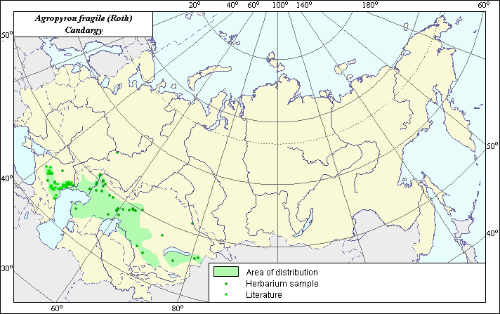 Object description Download GIS-layers
Author:
Expert on subject and GIS-expert - L.L. Malyshev.Date of creation:
07.07.2003Scale:
1:20,000,000.Accuracy of a map:
Created using maps of scale 1:12,000,000-1:40,000,000.Projection:
"Alber.s Equal Area Conic for the USSR ", 9, 1001, 7, 100, 0, 44, 68, 0, 0.Basic contents:
Vector map. The area of species is designated by a polygon.Accuracy of classifier:
Species distribution is based on location coordinates of germplasm accessions and herbarium specimens of the N.I. Vavilov Institute and published maps from: Grossgheim (1939); Buhteeva (1990) and Ivanov & Buhteeva (1975).Method of map production:
Published literature was reviewed, including atlases, monographs and papers. Occurrence data were obtained from herbarium specimens, floras, monographs and papers. Data were then compiled through scanning and geo-referencing to develop a composite vector map. The biologist, together with the GIS specialist, drew a new plant distribution area based on compiled data.Reference citations:
Buhteeva A.V., Malyshev L.L., Konarev A.V. 1990. Wild-growing populations of crested wheat grass from Eastern europian steppe province. Bull. VIR. Leningrad. N.198: 54-59.Grossgeim, A.A. 1939. Flora of Caucasus. Polypodiaceae-Gramineae. Baku: Publishing house AzFaN. V.2: 587 pp.
Ivanov A.I., Buhteeva A.V. 1975. Cenotic areas of the major fodder plants of Kazakhstan. Proc. Appl. Bot., Gen. and Breeding 54(3): 3-17.
N.I. Vavilov Institute of Plant Industry [WIR], St. Petersburg, Russia.