Relatives
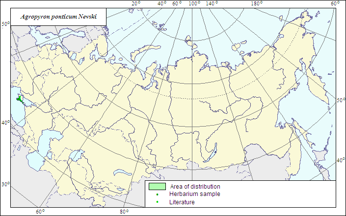
Range of distribution of Pontic Wheatgrass (Agropyron ponticum) .
 Object description Download GIS-layers
|
|

RelativesRange of distribution of Pontic Wheatgrass (Agropyron ponticum) . Object description Download GIS-layers
Author:The expert-botanist and the GIS expert - L.L.Malyshev.Date of creation:25.06.07Scale:1:20 000 000.Accuracy of the map:The map is based on data of 1:12 000 000-1:40 000 000 scale maps.Projection:"Albers Equal-Area Conic Projection for USSR", 9, 1001, 7, 100, 0, 44, 68, 0, 0Basic contents:The map is a vector file consisting of 1 basic and 3 subject layers. The species range is represented by a polygon and dots.Accuracy of the qualifier:The dots represent information on the species localities according to herbarium materials of LE (1) and published sources (2), the polygon - generalized information on the species distribution.Method of the map contruction:The range map is based on coordinates according to herbarium materials of V.L.Komarov Botanical Institute (LE) and published maps (Shelyag-Sosonko, 1977). The species range covers mountains and piedmont of Crimea. Sometimes is treated within an ancient Circumpontic species Agropyron brandzae Pantu et Solacola, the latter embodying A.brandzae, A.ponticum, A.pinifolium; however, these species are more likely comparatively young separate taxa, which have formed convergently under similar ecological conditions on the base of A.pectinatum.References:Shelyag-Sosonko YuR., ed. Grasses of Ukraine. 1977. Kiev: Naukova Dumka. 518 p. (In Russian).Rights and copyrights:The copyrights of the map and descriptions are held by their author. |
|
|
|
|
Web design — |