
Relatives
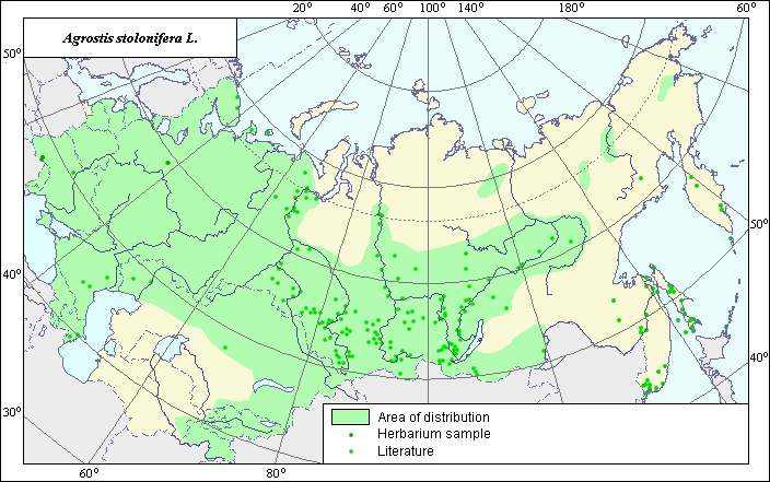
Area of Agrostis stolonifera L.
 Object description Download GIS-layers
Author:
Scientist - V.G. Funtova.Data of creation:
25.11.2003.Scale:
1:20,000,000.Accuracy of map:
The map was created using maps that had a scale of 1:50,000,000, 1:30,000,000, 1:10 000,000, 1:5,000,000.Projection:
.Alber's Equal Area Conic for Russia,. 9, 1001, 7, 100, 0, 44, 68, 0, 0.Basic contents:
Vector map. Points represent locations of species; area of possible distribution of species is represented by polygon.Accuracy of classifier:
Light-colored points are locations of species obtained from the literature (Malyshev & Peshkova, 1990); (Malyshev & Peshkova, 1979); (Harkevich, 1982); (Hulten & Fries, 1986). Dark-colored points are locations of species obtained from herbarium specimens and germplasm accessions from the N.I.Vavilov All-Russian Research Institute of Plant Industry. Polygons were created using data about the distribution of species in floristic regions according to the following sources: (Author, 1974); (Ramenskaya, 1983); (Grossgheim, 1939); (Tzvelev, 1976); (Hulten & Fries, 1986).Method of map production:
Published literature was reviewed, including Atlases, monographs and papers. Occurrence data were obtained from herbarium specimens, floras, monographs and papers. Data were then compiled through scanning and geo-referencing to develop a composite vector map. The biologist, together with the GIS specialist, drew a new plant distribution area based on compiled data. Map boundaries were determined as follows: For an accurate definition of the western and southern borders (state border of Russia was used); for the eastern border (Malyshev & Peshkova, 1990), (Malyshev & Peshkova, 1979), (Hulten & Fries, 1986); for the southwestern border (Mayshev & Peshkova, 1990), (Hulten & Fries, 1986), (Tzvelev, 1976); for the northern border (Malyshev & Peshkova, 1990), (Hulten & Fries, 1986), (Fedorov, 1974), (Ramenskaya, 1983). The boundaries of the three small polygons were determined according to: (Chochrjakov, 1985); (Hulten & Fries, 1986). Several points were not included in polygon area as they were considered possible invasion. Area map also takes into account ecology data from the .Description..Reference citations:
Chochrjakov, A.P. 1985. Flora of Magadan distict. M.: Nauka. 397 pp. (in Russian).
Fedorov, A., ed. 1974. Flora of the European part of the USSR. Leningrad: Nauka. V.1: 404. (in Russian).
Grossgheim, A.A. 1939. Flora of Caucasia. Baku. V.1: 402 pp. (in Russian).
Harkevich S.S., ed. 1982. Wild fodder grass of Far East. Moscow: Nauka. 240 pp. (in Russian).
Hulten E., Fries M. 1986. Atlas of north European vascular plants north of the Tropic of Cancer. Konigstein. V. 1-3: 1172 p.
Malyshev, L.I. & G.A. Peshkova, ed. 1979. Flora of Central Siberia. Novosibirsk: Nauka. V.1: 536 pp. (in Russian).
Malyshev, L.I. & G.A. Peshkova, ed. 1990. Flora of Siberia. Poaceae (Graminea). Novosibirsk: Nauka. V.2: 361. (in Russian).
N.I. Vavilov All-Russian Research Institute of Plant Industry [WIR], St. Petersburg, Russia.
Ramenskaya I.L. 1983. Analysis of flora Murmansk district and Karelia. L.: Nauka. 216 pp. (in Russian).
Tzvelev N.N. 1976. Poaceae USSR. L.: Nauka. 788 pp. (in Russian).
Right and copyright:
Copyright on this map and description belongs to its authors.© Photo: http://www.ulsamer.at/db/agrostis-stolonifera-1.jpg