
Relatives
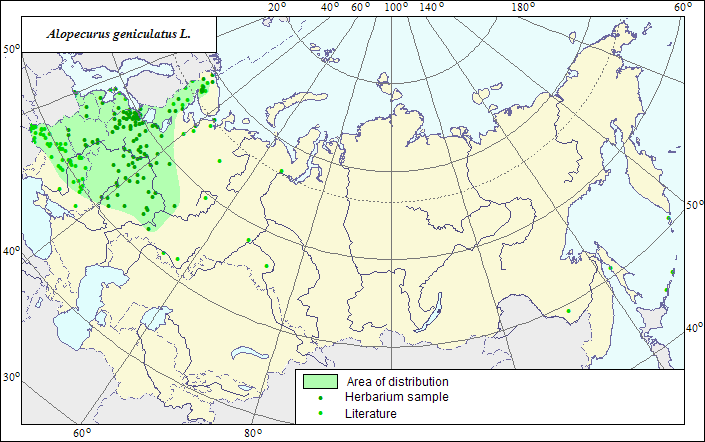
Range of distribution of Bent Foxtail, Marsh Foxtail (Alopecurus geniculatus) .
 Object description Download GIS-layers
Author:
The expert-botanist and the GIS expert - L.L.Malyshev.Date of creation:
25.12.2007Scale:
1:20 000 000.Accuracy of the map:
The map is based on data of 1:12 000 000-1:40 000 000 scale maps.Projection:
"Albers Equal-Area Conic Projection for USSR", 9, 1001, 7, 100, 0, 44, 68, 0, 0Basic contents:
The map is a vector file consisting of 1 basic and 3 subject layers. The species range is represented by a polygon and dots.Accuracy of the qualifier:
The dots represent information on the species localities according to herbarium materials of LE (1) and published sources (2), the polygon - generalized information on the species distribution.Method of the map contruction:
The range map is based on coordinates according to herbarium materials of V.L.Komarov Botanical Institute (LE), and published maps (Shelyag-Sosonko, 1977; Kharkevich, 1985). The species range covers the zones of broad-leaved and coniferous-broad-leaved forests, and partly the southern taiga zone from the western border of the former USSR to the Middle Volga area. Naturalized enough, though alien, populations of Alopecurus geniculatus have formed new parts of its range in the northern Karelia, on Kola Peninsula and in the Far East.References:
Shelyag-Sosonko YuR., ed. Grasses of Ukraine. 1977. Kiev: Naukova Dumka. 518 p. (In Russian).Kharkevich SS., ed. 1985. Vascular plants of the Soviet Far East. V.1. Leningrad: Nauka. 398 p. (In Russian).
Rights and copyrights:
The copyrights of the map and descriptions are held by their author.The copyright of the photo is held by N.Yu.Malysheva, L.L.Malyshev.