
Relatives
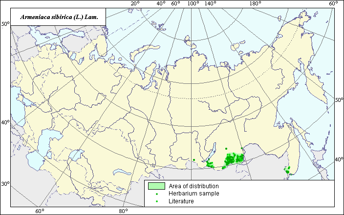
The area of Siberian apricot (Armeniaca sibirica (L.) Lam.)
 Object description Download GIS-layers
Authors:
The expert-botanist - Chuhina I.G., theGIS-Expert - Bagmet L.V.
Date of creation:
25.11.2004Scale:
1:20 000 000.Accuracy of map:
Map was created based on data from herbarium specimens and on maps having the following scale: 1:20 000 000-1:50 000 000.The projection:
"Alber's Equal Area Conic for Russia", 9, 1001, 7, 100, 0, 44, 68, 0, 0Basic contents:
Vector map. Area of species distribution is shown by polygons and actual location occurrence is shown by points.Accuracy of classifier:
Point data were obtained from literature sources and herbarium specimens. Polygons are based on literature sources, herbarium samples, and field surveys by the authors.Method of map production:
Published literature was reviewed, including Atlases, monographs and papers. Occurrence data were obtained from herbarium specimens, floras, monographs and papers. The following sources were used to determine the area of distribution of this species: N.I. Vavilov Institute (1999), Sokolov et al. (1980), Kharkevich (1996), Koropachinskiy & Vstovskaya (2002), Malyshev & Peshkova (1988). The area of Armeniaca sibirica in the territory of Russia is presented as three isolated parts: two of them are in Eastern Siberia (southern Transbaikalia) and the third one is in the south of the Far East. The western border of the most western part of the area was determined according to Malyshev & Peshkova (1988), the east border according to Sokolov et al. (1980). Northern border is expanded based on herbarium materials stored in the database of the N.I. Vavilov Institute (1999). Northern border of the other Siberian part of the area was determined according to Sokolov et al. (1980), the western border was adjusted according to herbarium materials. Borders of the Far East part of the area were determined according to the following sources: Kharkevich (1996), Sokolov et al. (1980) and Koropachinskiy & Vstovskaya (2002). The north-west border of the Far East part of the area was determined according to herbarium materials stored in the database of the N.I. Vavilov Institute (1999). Data were then compiled through scanning and geo-referencing to develop a composite vector map. The biologist, together with the GIS specialist, drew a new plant distribution area based on compiled data.Reference citations:
Central Siberian Botanical Garden [NS], Novosibirsk, Russia.Far Eastern Branch, Russian Academy of Sciences, Institute of biology and soil science [VLA], Vladivostok, Russia.
Kharkevich S.S., ed. 1996. Vascular plants of the Soviet Far East. V. 8. Leningrad: Nauka. 241 p. (In Russian)
Koropachinskiy I.Yu., Vstovskaya T.N. 2002. Woody plants of the Asian part of Russia. Novosibirsk: Publishing House of SB RAS, Branch "Geo". 299 p. (In Russian)
Malyshev, L.I. & G.A. Peshkova, ed. 1988. Flora of Siberia. Rosaceae. V. 8. Novosibirsk: Nauka. Map # 144. (In Russian)
N.I. Vavilov All Russian Institute of Plant Industry [WIR], St. Petersburg, Russia.
N.I. Vavilov Institute, Herbarium Department, 1999. Information retrieval system: wild-growing relatives of cultural plants of Russia. STC Informregistr 0229905883, St. Petersburg, Russia.
Sokolov S.I., Svjaseva O.A., Kubli V.A. 1980. Areas of distribution of trees and shrubs in the USSR. V. 2. Leningrad: Nauka. Map # 98D. (In Russian)
Tomsk State University [TK], Tomsk, Russia.
V.L. Komarov Botanical Institute [LE], St. Petersburg, Russia.