
Relatives
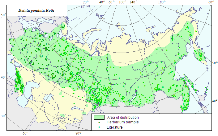
Range of distribution of Betula pendula Roth. (Silver birch, weeping birch)
 Object description Download GIS-layers
Authors:
The expert-botanist - I.G.Chukhina,the GIS expert - L.V.Bagmet.
Date of creation:
12.02.2007Scale:
1:20 000 000.Accuracy of the map:
The map is based on data of herbarium specimens and on 1:13 00 000 - 1:86 000 000 scale maps.Projection:
"Albers Equal-Area Conic Projection for USSR", 9, 1001, 7, 100, 0, 44, 68, 0, 0Basic contents:
The map is a vector file consisting of a polygon and dots. The localities of the species are represented by the dots; the area of species distribution is represented by the polygon.Accuracy of the qualifier:
The dots represent information on the species localities according to published sources and herbarium specimens. The polygon is based on generalized information from published sources and herbarium specimens.Method of the map contruction:
The data on the species distribution were obtained from the database of the species localities coordinates included in the Information Retrieval System "Crop Wild Relatives in Russia" (STC Informregistr 0229905883, 1999), and from the published maps by Grossheim (1945), N.I.Orlova and A.A.Kustysheva in "Flora of the Northeast of European part of the USSR" (1976), P.B.Klimov in "Vascular plants of the Soviet Far East" (1996), M.A.Shemberg in "Flora of Siberia" (1992), Vasilyukhina (1969), A.K.Skvortsov in "Ranges of trees and shrubs of the USSR" (1980), Koropachinskiy and Vstovskaya (2002).In the European part, the northern range border is drawn in Kola Peninsula according to LE Herbarium materials referred to in the database of the Information Retrieval System; in the Arkhangelsk Region after Orlova and Kustysheva (1976); the southern border after Skvortsov (1980), and corrected according to LE Herbarium materials. The range borders in the Caucasus are drawn after Grossheim (1945). The solitary locality in the Crimea, isolated from the main range, is represented by a dot in the map and not included in the polygon. The range borders in its Siberian part are drawn after Shemberg (1992) and Vasilyukhina (1969). The range borders in its Far Eastern part are constructed after Klimov (1996).
References:
Grossheim AA. 1945. Flora of Caucasus. 2nd ed. V.3. P.46. Map 32. (In Russian).Herbarium specimens of V.L.Komarov Botanical institute [LE], St.Petersburg, Russia.
Kharkevich SS., ed. 1996. Vascular plants of the Soviet Far East. V.8. Leningrad: Nauka. P.20-21. (In Russian).
Koropachinskiy IYu., Vstovskaya TN. 2002. Woody plants of the Asian part of Russia. Novosibirsk: Publishing House of Siberian Division of the Russian Academy of Science, Branch "Geo". P.195-197. (In Russian).
N.I.Vavilov All-Russian Institute of Plant Industry, Herbarium Department, 1999. Information Retrieval System: Crop Wild Relatives in Russia. STC Informregistr 0229905883, St.Petersburg, Russia.
Sokolov SI., Svjaseva OA., Kubli VA. 1980. Ranges of trees and shrubs of the USSR. V.2. Leningrad: Nauka. P.96-97. (In Russian).
Tolmachev AI., ed. 1976. Flora of the North-East of European part of the USSR. V.2. Leningrad: Nauka. P.157. (In Russian).
Krasnoborov IM., Malyshev LI., ed. 1992. Flora of Siberia. V.5. Salicaceae - Amaranthaceae. Novosibirsk: Nauka. P.69-70. (In Russian).
Vasilyukhina MA. 1969. Southern limits of distribution of boreal flora elements in the southern West Siberia and in northern Kazakhstan. In: Tolmachev AI., ed. Ranges of plants of the USSR flora. Leningrad: Leningrad University Publ. P.195-228. (In Russian).