
Relatives
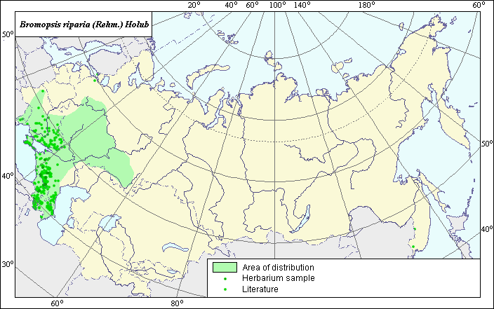
Distribution area of Bromopsis riparia (Rehm.) Holub
 Object description Download GIS-layers
Author:
V.G. FuntovaData of creation:
28.10.2003.Scale:
1:20,000,000.Accuracy of map:
The map was created using maps of scales 1:50,000,000, 1:30,000,000, 1:10,000,000, and 1:5,000,000.Projection:
.Alber's Equal Area Conic for Russia., 9, 1001, 7, 100, 0, 44, 68, 0, 0.Basic contents:
Vector map. Area of species distribution is shown by polygons; actual locations of species are shown by points.Accuracy of classifier:
Point data were obtained from published sources and herbarium specimens. Polygons are based on published sources, herbarium samples, and field surveys by the authors. Light-colored points represent locations of the species identified in publications. Dark-colored points represent locations of species from which herbarium specimens were taken (N.I. Vavilov Institute).Method of map production:
Published literature was reviewed, including atlases, monographs and papers. Occurrence data were obtained from herbarium specimens, floras, monographs and papers. Distribution points representing species locations were determined using the following published sources: Grossgheim (1939), Shelyak-Sosonko (1977), Harkevich (1991), Tolmachev (1974), and Tzvelev (1976). In addition, species locations were determined using specimens from the herbarium of the N.I. Vavilov All-Russian Research Institute of Plant Industry. Polygon areas were determined using Tolmachev (1974) and Tzvelev (1976). The final distribution area is the result of integrating various maps: for the western border - the state border of Russia; for the northwestern border - Shelyak-Sosonko (1977); and for the southwestern border - Grossgheim (1939); for the northeastern, southeastern, and eastern borders - Tzvelev (1976) and Tolmachev (1974). Several points were not included in the main distribution area, as they were considered invasions. Data were then compiled through scanning and geo-referencing to develop a composite vector map. The biologist, together with the GIS specialist, drew a new plant distribution area based on compiled data.Reference citations:
Grossgheim A.A. 1939. Flora of Caucasia. V. 1. Baku, 402 pp. (In Russian).Harkevich S.S., ed. 1991. Vascular Plants of the Soviet Far East. V. 5. Saint Petersburg: Nauka, 390 pp. (In Russian).
N.I. Vavilov All-Russian Institute of Plant Industry [WIR], St. Petersburg, Russia.
Shelyak-Sosonko, Y.P., ed. 1977. Poaceae Ukraina (Grasses of Ukraine). Kiev: Naukova Dumka. 518 pp. (In Russian).
Tolmachev, A.I., ed. 1974. Flora of the European part of the USSR. V. 1. Leningrad: Nauka, 404 pp. (In Russian).
Tzvelev N.N. 1976. Poaceae USSR. Leningrad: Nauka, 788 pp. (In Russian).