
Relatives
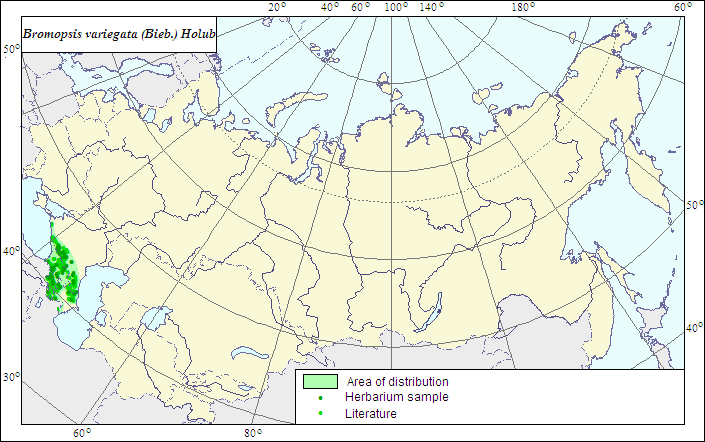
Range of distribution of Variegated Brome (Bromopsis variegata (Bieb.) Holub).
 Object description Download GIS-layers
Authors:
The expert-botanists - N.I.Dzyubenko, E.A.Dzyubenko.The GIS expert - A.N.Dzyubenko.
Date of creation:
17.06.2007Scale:
1:20 000 000.Accuracy of the map:
The map is based on data of a 1:13 000 000 scale map, specified according to herbarium materials.Projection:
"Albers Equal-Area Conic Projection for USSR", 9, 1001, 7, 100, 0, 44, 68, 0, 0Basic contents:
The map is a vector file consisting of 1 basic and 2 subject layers. The species range is represented by a polygon and dots.Accuracy of the qualifier:
The dots represent information on the species localities: 1 - reliable data from herbarium and published sources; the polygon (1) - generalized information on the species distribution from published sources and herbarium specimens.Method of the map construction:
The data from the herbarium materials of LE, published map of the range (Grossheim, 1939), and published data (Rozhevits, Shishkin, 1934; Tzvelev, 1976; Brezhnev, Korovina, 1981) were used for constructing the range of Bromopsis variegata. Endemic to the Caucasus. The range consists of one polygon and dots. The species is confined to the high montane zone and forms subalpine and alpine meadows.References:
Brezhnev DD., Korovina ON. 1981. Wild relatives of cultivated plants of the USSR flora. Leningrad: Kolos. 375 p. (In Russian).Grossheim AA. 1939. Flora of Caucasus. 2nd ed. V.1. 402 p. (In Russian).
Rozhevits RYu., Shishkin BK., eds. 1934. Flora URSS. V.2. 778 p. (In Russian).
Tzvelev NN. 1976. Grasses of the Soviet Union. Leningrad: Nauka. 788 p. (In Russian).
Herbarium specimens of V.L.Komarov Botanical Institute [LE], St.Petersburg, Russia.
Rights and copyrights:
The copyrights of the map and descriptions are held by their authors.The copyright of the photo is held by E.A.Dzyubenko.