
Relatives
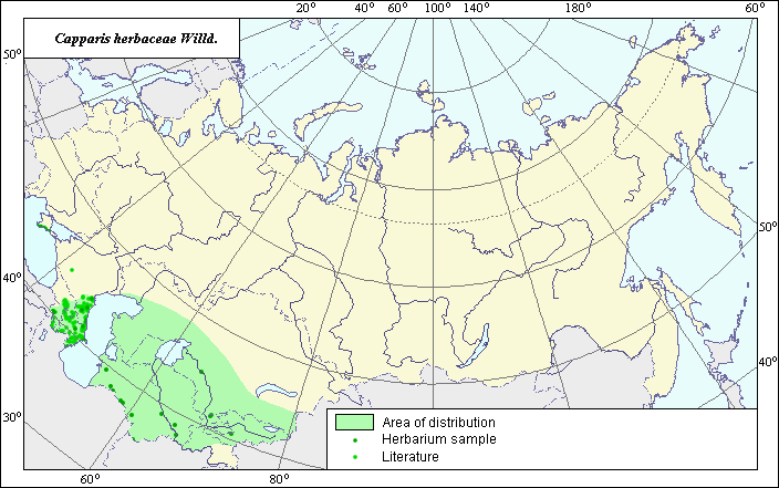
The area of Capparis herbacea Willd. (Caper tree, common capers).
 Object description Download GIS-layers
Authors:
The expert-botanist - T.N. Smekalova, the GIS-expert - G.V. Talovina.Date of creation:
03.11.2004.Scale:
1:20 000 000.Accuracy of a map:
Map is based on data from herbarium specimans and specified on maps having the following scale - 1:10 000 000.The projection:
"Alber's Equal Area Conic for Russia", 9, 1001, 7, 100, 0, 44, 68, 0, 0.Basic content:
Map is a vector fail consisting of polygon and points. Locations of species are represented by points, area of possible distribution of species are represented by polygon.Accuracy of the qualifier:
Lidht-colored points are locations referenced in literature sources. Dark-colored points are locations of species that were reported from herbarium samples. Polygon is based on generalized information from literature sources, herbarium specimans, political boundaries and ecological description.Method of map construction:
As materials for development of species area map materials from herbarium collections (Komarov Botanical Institute, Moscow State University, Vavilov Institute of Plant Industry), the published maps of area (Grossheim, 1950), the consultations of expert N.I. Dzyubenko, and the literary data (Flora of the USSR, 1939, Flora of Tadjikistan, 1975, the Manual of plants of Middle Asia, 1988) have served. The area of species consists of three ranges - Crimean, Caucasian and Central Asian. The Crimean range covers a southern part of the Crimean peninsula, Caucasian - practically all territory of Caucasus within the limits of the former USSR. Thus in mountain areas the species does not rise above the average a mountain belt. In the Central Asian part of the former USSR the species occupies practically all territory of Middle Asia, except for high mountains of Pamir. Thus by results of VIR expedition to Pamir of 2003 it is known, that plants of species in this territory are found on coast of the river Vakhsh. To the south the species is not found out. In northern part of an area the species reaches up to Kazakh cone-shaped hills zone, but does not come to the north of southern spurs of the Ural mountains. In northeast the species grasps the south of Kazakhstan, not reaching up to lake Balkhash. The southern border of the area is limited by state frontier of former USSR. The points which were not included into borders of ranges, represent invasive habitats of species.Sources of the data:
Cherepanov, S.K. 1995. Plantae Vasculares Rossicae et Civitatum Collimitanearum (in limicis USSR olim). St-Petersburg, "Mir I Semia", 990 p. (in Russian).Flora of Kazakhstan. 1970, Goloskokov (ed.). - Alma-Ata, Т.4, p. 161.
Flora USSR, 1939. Vol. VIII. Komarov V.L. (ed.) - M.-L.: Publishing House of Acad. Science, pp. 2-3. (in Russian).
Galushko, A.I. 1980. Flora of Northern Caucasia. Vol.II. Rostov, Publishing house of Rostov State University, p. 64-65. (in Russian).
Grossgeim, A.A. 1950. Flora of Caucasia. - Baku, Publishing House of Acad. Science of the USSR, Vol. IV, 253 p., appendix. (in Russian).
Herbarium Specimans - Moscow State University (Russia), All-Russian Vavilov Institute ot Plant industry (SPb, Russia), Komarov Botanical Institute (SPb, Russia).
Nikitin, V.V., Geldihanov A.M. 1988. The Manual of plants of Turkmenistan. L.: Nauka, p. 635.
Nikitin, V.V., Geldihanov A.M. 1988. The Manual of plants of Turkmenistan. - L.: Nauka, p. 237.
The Manual of Middle Asia plants. 1974. M.G. Pahomova (ed.) - Tashkent, "Fan", Vol. IV, p. 30-31. (in Russian).
Right and copyright:
Copyright on this map and description belongs to its authors.Copyright on this picture belongs to Sergey Shuvalov.