
Relatives
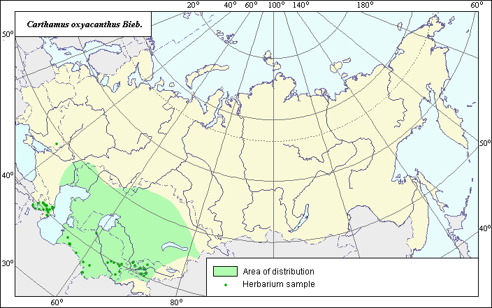
The area of Carthamus oxyacanthus Bieb. (Sharp-thorn safflower)
 Object description Download GIS-layers
Authors:
The expert-botanist - T.N. Smekalova,the GIS-expert - G.V. Talovina.
Date of creation:
06.09.2004Scale:
1:20 000 000.Accuracy of map:
Map was created based on data from literature and herbarium specimens.The projection:
"Alber's Equal Area Conic for Russia", 9, 1001, 7, 100, 0, 44, 68, 0, 0Basic contents:
Vector map. Area of species distribution is shown by polygons and actual location occurrence is shown by points.Accuracy of classifier:
Point data were obtained from literature sources and herbarium specimens. Polygons are based on literature sources, herbarium samples, and field surveys by the authors. Dark-colored points represent locations of species that were reported from herbarium samples (Moscow State University, N.I. Vavilov All-Russian Institute of Plant Industry, V.L. Komarov Botanical Institute). Polygon was created based on generalized information from literature sources, herbarium specimens, political boundaries and ecological descriptions.Method of map production:
Published literature was reviewed, including Atlases, monographs and papers. Occurrence data were obtained from herbarium specimens, floras, monographs and papers. The general distribution area of Carthamus oxyacanthus was determined according to data from the V.L. Komarov Botanical Institute, the N.I. Vavilov Institute of Plant Industry and the Moscow State University Herbariums. The area consists of two polygons, the Caucasian and Middle Asian polygons. The Caucasian polygon includes the eastern part of the pre-Caucasis territory and the Eastern Back-Caucasis while the middle Asian includes a significant part of the Middle Asia territory. According to the following literature data, the species is distributed throughout the territory of Middle Asia including Tjan-Shan, Pamiro-Alai and Mountain Turcmenia: Bobrov & Cherepanov (1963), Nikitin & Geldihanov (1988), Cherepanov (1995). The Manual of Plants of Middle Asia (Adylov & Tsukeravnik, 1993) provided the most careful distribution of the species in the territory of Middle Asia. Data were then compiled through scanning and geo-referencing to develop a composite vector map. The biologist, together with the GIS specialist, drew a new plant distribution area based on compiled data.Reference citations:
Adylov T.A., Tsukeravnik G.A., ed. 1993. The Manual of Middle Asia plants. V. 10. Tashkent: Fan. 428-429 p. (In Russian)Bobrov, E.G. & S.K. Cherepanov, ed. 1963. Flora USSR. V. 28. Moscow-Leningrad: Publishing House of Acad. Science. 583-584 p. (In Russian)
Cherepanov S.K. 1995. Plantae Vasculares Rossicae et Civitatum Collimitanearum (in limics USSR olim)[List of Vascular Plants of Russia]. St. Petersburg: Mir I Semia. 990 pp. (In Russian)
Moscow State University [MWG], Moscow, Russia.
N.I. Vavilov Institute All-Russian of Plant Industry [WIR], St. Petersburg, Russia.
Nikitin V.V., Geldihanov A.M. 1988. The Manual of plants of Turkmenistan. Leningrad: Nauka. 635 p.
V.L. Komarov Botanical Institute [LE], St. Petersburg, Russia.
Wulf V.V., Maleeva O.F. 1969. The World Resources of the Useful Plants. Leningrad: Nauka. 427-428 p. (In Russian)