
Relatives
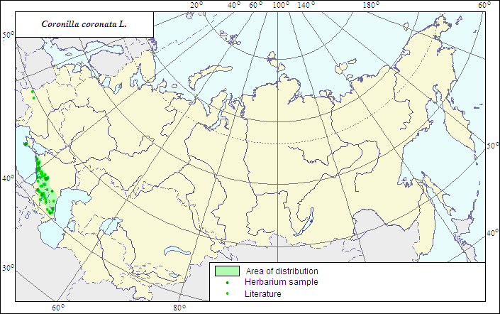
Range of distribution of Coronilla coronata L. (Crowned Scorpion-vetch)
 Object description Download GIS-layers
Authors:
The expert-botanist - T.N.Smekalova,the GIS expert - G.V.Talovina.
Date of creation:
07.05.2007Scale:
1:20 000 000.Accuracy of the map:
The map is based on data of a 1:10 000 000 scale map, specified according to herbarium materials.Projection:
"Albers Equal-Area Conic Projection for USSR", 9, 1001, 7, 100, 0, 44, 68, 0, 0Basic contents:
The map is a vector file consisting of a polygon and dots. Point localities of the species are represented by dots; the area of possible species distribution is represented by the polygon.Accuracy of the qualifier:
Dark dots represent information on the species localities from herbarium specimens, the light dots represent data from published sources; the polygon is based on generalized information from published sources and herbarium specimens.Method of the map contruction:
The species prefers slopes of the lower and middle montane zones of the Crimean and Caucasian mountains. The species range consists of two polygons - Crimean and Caucasian - and separate dots in the South Transcaucasia and in Podolia (West Ukraine). The Crimean polygon includes the species localities in the southern, mountain part of the Crimean Peninsula, and is constructed by means of generalization of factual data available in the herbarium collections of WIR and LE, as well as published data (Fedorov, Tzvelev, 1987). The northern part of the Caucasian polygon covers the North Caucasus and is drawn according to materials of a published map of the species range (Grossheim, 1952), factual data on the species localities in WIR and LE Herbaria, and published data (Galushko, 1980). The southern border of the polygon is drawn according to data of WIR and LE herbarium collections and materials of a published map of the species range (Grossheim, 1952). The species distribution in the east and west is limited by the Black and Caspian Seas, so the western and the eastern borders of the polygon coincide with coastlines. An essential part of the general species range is situated in the southern part of the Central and Western Europe. Separate dots in the Lvov and Ternopol Regions (data of Roskov et al., 2005) where, according to "Manual of higher plants of Ukraine" (1987), the species occurs rarely, are located at the northern border of the species range.References:
Galushko AI. 1980. Flora of the North Caucasus: Handbook. V.2. P.161. (In Russian).Grossheim AA. 1952. Flora of Caucasus. 2nd ed. V.5. P.347. (In Russian).
Roskov YR. et al. 2005. ILDIS World Database of Legumes. Available at: http://www.ildis.org/LegumeWeb?version~10.01&LegumeWeb&tno
Dobrochaeva DN., Kotov MI., Prokudin YuN. 1987. Manual of higher plants of Ukraine. Kiev: Naukova Dumka. P.198-199. (In Russian).
Fedorov AA., Tzvelev NN., ed. 1987. Flora of the European part of the USSR. V.6. Leningrad: Nauka. P.121-122. (In Russian).
Shishkin BK., Bobrov EG., ed. 1948. Flora URSS. V.13. P.249-250. (In Russian).
Cherepanov SK. 1995. Vascular plants of Russia and adjacent states (the former USSR). St.Petersburg. 990 p. (In Russian).
Herbarium materials of N.I.Vavilov All-Russian Institute of Plant Industry [WIR], V.L.Komarov Botanical institute [LE], (both in St.Petersburg, Russia).