
Relatives
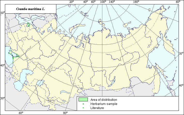
The distribution area of Sea kale (Crambe maritima L.)
 Object description Download GIS-layers
Authors:
The expert-botanist T.N. SmekalovaThe GIS-expert G.V. Talovina
Date of creation:
19.11.2003Scale:
1:20,000,000.Accuracy of map:
The map was created using published maps of scale 1:10,000,000 and herbarium materials.The projection:
"Alber's Equal Area Conic for Russia", 9, 1001, 7, 100, 0, 44, 68, 0, 0.Basic contents:
Vector map. Area of species distribution is shown by polygons; actual species locations are shown by points.Accuracy of classifier:
Point data were obtained from published sources and herbarium specimens. Dark green points represent locations from which herbarium specimens were taken, and the remaining points represent locations of the species as reported in publications. Polygons are based on published sources, herbarium samples, and field surveys by the authors.Method of map production:
Published literature was reviewed, including atlases, monographs and papers. Occurrence data were obtained from herbarium specimens, floras, monographs and papers. Points indicating occurrence of species are based on information from the following published and herbarium sources: Green points from Grossgeim (1950); blue points from the herbarium at the V.L. Komarov Botanical Institute; red points represent herbarium data from the N.I. Vavilov All-Russian Institute of Plant Industry, Rostov's Botanical Garden and St. Petersburg State University. Polygons were constructed using data about species distribution across floristic regions. References used include Grossgeim (1950), Bush (1939) and Dorofeev (1998, 2002). The species has a disjunctive distribution area. The area consists of two separated contours, which are located in the European region of former USSR: the territory around the Black Sea (including Crimea) and the northeast coast of the Riga Gulf (including Saaremaa Island). Specific features of this area are explained by the rigid preference of the species for the seaside sand of Europe (Bush, 1939). Data were then compiled through scanning and geo-referencing to develop a composite vector map. The biologist, together with the GIS specialist, drew a new plant distribution area based on compiled data.Reference citations:
Bush N.A., ed. 1939. Flora of the USSR. Cruciferae. Moscow-Leningrad. V. 8: 600-602. In Russian.Dorofeev V.I. 1998. Family Cruciferae (Brassicaceae) Middle Zone of the European Part of the Russian Federation. Turchaninowia: Barnaul. V. 1(3): 94. In Russian.
Dorofeev V.I. 2002. Cruciferae (Brassicaceae) of European Russia. Turchaninowia: Barnaul. V. 5(3): 115. In Russian.
Grossgeim, A.A. 1950. Flora of the Caucasus. Moscow-Leningrad: Publishing House of Acad. Science. 175 p.
N.I. Vavilov All-Russian Institute of Plant industry [WIR], St. Petersburg, Russia.
Rostov.s Botanical Garden, Rostov-on-Don, Russia.
St. Petersburg State University [LECB], St. Petersburg, Russia.
V.L. Komarov Botanical Institute [LE], St. Petersburg, Russia.