
Relatives
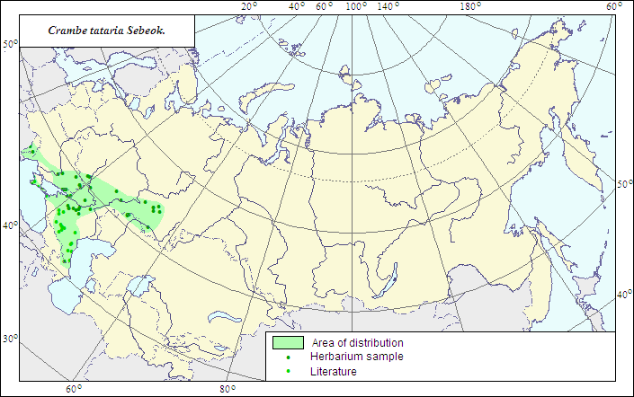
Range of distribution of Crambe tataria Sebeok. (Tatarian Sea-kale)
 Object description Download GIS-layers
Authors:
The expert-botanist - T.N.Smekalova,the GIS expert - G.V.Talovina.
Date of creation:
20.05.2007Scale:
1:20 000 000.Accuracy of the map:
The map is based on data of a 1:10 000 000 scale map, specified according to herbarium materials.Projection:
"Albers Equal-Area Conic Projection for USSR", 9, 1001, 7, 100, 0, 44, 68, 0, 0Basic contents:
The map is a vector file consisting of a polygon and dots. Point localities of the species are represented by dots; the area of possible species distribution is represented by the polygon.Accuracy of the qualifier:
Dark dots represent information on the species localities from herbarium specimens, the rest (light) dots represent data from published sources; the polygon is based on generalized information from published sources and herbarium specimens.Method of the map construction:
In the former USSR, this South European - ancient Mediterranean species (Gubanov et al., 2003) is mainly restricted within steppe zone of Russia, Caucasian foothills (Ciscaucasia) and the southern part of Crimean Peninsula. The species range is represented by two polygons, Crimean and European-Caucasian. The European-Caucasian polygon includes the species localities in steppe zone of southern Russia, the southern Cisural area and foothills of Caucasus. In the northern part of the polygon, the species, according to herbarium data, does not penetrate northward beyond the southern part of forest-steppe zone. Its distribution in the east is limited by the Ural Range; in the south, according to published (Grossheim, 1950) and factual (herbarium) data, by Caucasian mountains. In the western part of the main polygon, the species reaches the former state border of the USSR south of Kishinev (Moldova). The Crimean polygon covers the southern Crimean Peninsula where the species occurs on dry steppified or debris slopes. Factual data of LE, RV, VOR and KAZ Herbaria, data of a published map of the species range (Grossheim, 1950), and published data (Dobrochaeva et al., 1987; Gubanov et al., 2003; Mayevsky, 2006) served the base of the range construction.References:
Geideman TS. 1975. Manual of higher plants of Moldavian Soviet Socialist Republic. Kishinev: Shtiintsa. 574 p. (In Russian). p.225.Gubanov IA., Kiseleva KV., Novikov VS., Tikhomirov VN. 2003. Illustrated Manual of the Middle Russia Plants. V.2. Moscow: KMK. P.501. (In Russian).
Grossheim AA. 1950. Flora of Caucasus. 2nd ed. V.4. P.175-176. (In Russian).
Dobrochaeva DN., Kotov MI., Prokudin YuN. 1987. Manual of higher plants of Ukraine. Kiev: Naukova Dumka. P.113. (In Russian).
Mayevsky PF. 2006. Flora of the middle zone of European part of Russia. 10th ed. Moscow. 600 p. (In Russian).
Fedorov AA., ed. 1979. Flora of the European part of the USSR. V.4. Leningrad: Nauka. P.51. (In Russian).
Busch NA., ed. 1939. Flora URSS. V.8. P.484. (In Russian).
Cherepanov SK. 1995. Vascular plants of Russia and adjacent states (the former USSR). St.Petersburg. 990 p. (In Russian).
Herbarium materials of V.L.Komarov Botanical institute [LE], St.Petersburg; Rostov (RV), Voronezh (VOR) and Kazan (KAZ) State Universities (all in Russia).