
Relatives
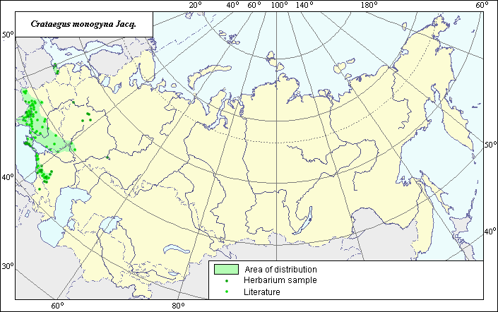
The distribution area of Common hawthorn, may. (Crataegus monogina Jacq.)
 Object description Download GIS-layers
Authors:
The expert-botanist I.G. ChuhinaThe GIS-Expert O.V. Pereloma
Date of creation:
17.03.2005.Scale:
1:20,000,000.Accuracy of map:
Map is based on data from herbarium specimens and on maps of scale 1:13,000,000-1:25,000,000.The projection:
"Alber's Equal Area Conic for Russia", 9, 1001, 7, 100, 0, 44, 68, 0, 0.Basic contents:
Map is a vector file consisting of a polygon and points. Locations of species are represented by points; region of possible distribution of species is represented by a polygon.Accuracy of qualifier:
Points represent locations of the species referenced in published sources and locations from which herbarium specimens were taken. Polygon is based on generalized information from published sources and herbarium specimens.Method of map construction:
The data on species distribution were obtained from a database of site coordinates of the species, the Information Retrieval System "Wild-growing relatives of cultural plants of Russia" (NTC "Informregistr" № 0229905883) and published maps by Grossgeim (1952) and Sokolov et al. (1980). In the Caucasus, the northern, southern and southeastern borders of the distribution area were constructed in accordance with information from herbarium specimens at National Moscow University, Herbarium of the N.I. Vavilov All-Russian Institute of Plant Industry and Komarov Botanical Institute (Saint Petersburg). This information is stored in the IRS database. The western and southwestern borders of the distribution area were drawn in accordance with a map published by Grossgeim (1952). In the European region, all borders of the distribution area were mapped in accordance with Sokolov et al. (1980), except for the Kaliningrad province, where the borders of the area were constructed in accordance with information from herbarium specimens. This information is also stored in the IRS database. Points in central Russia were mapped in accordance with information from herbarium specimens. This information is likewise stored in the IRS database. These points lie outside the general distribution area.References:
Grossgeim, A.A. 1952. Flora of the Caucasus. Vol. 5. Moscow/Leningrad: Publishing House of the USSR Academy of Sciences, map # 46 (in Russian).Information Retrieval System (IRS). 1999. "Wild relatives of cultural plants of Russia". N.I. Vavilov All Russian Institute of Plant Industry (WIR) (St. Petersburg, Russia) NTC "Informregistr" № 0229905883.
Sokolov, S.I., Svjaseva, O.A., Kubli, V.A. 1980. Areas of distribution of trees and shrubs in the USSR. Vol. 2. Leningrad: Nauka, map # 66V.
Herbarium of the N.I. Vavilov All-Russian Institute of Plant Industry (WIR) (St. Petersburg, Russia), Komarov Botanical Institute (LE) (Saint Petersburg), The Biological Faculty of the Lomonosov State University of Moscow (MW).