
Relatives
Range of distribution of Horn-like Eurotia (Eurotia ceratoides ( L.) C.A.M.).
 Object description Download GIS-layers
Authors:
The expert-botanists - N.I.Dzyubenko, E.A.Dzyubenko.The GIS expert - A.N.Dzyubenko.
Date of creation:
17.12.2007Scale:
1:20 000 000.Accuracy of the map:
The map is based on data of a 1:40 000 000 scale map, specified according to herbarium materials.Projection:
"Albers Equal-Area Conic Projection for USSR", 9, 1001, 7, 100, 0, 44, 68, 0, 0Basic contents:
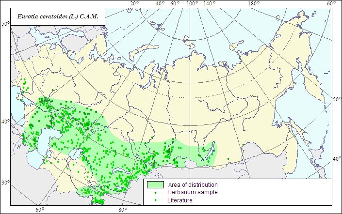
The map is a vector file consisting of 1 basic and 2 subject layers. The species range is represented by a polygon and dots.Accuracy of the qualifier:
The dots represent information on the species localities: reliable data according to herbarium (1) and published sources (2); the polygons - generalized information on the species distribution from published and herbarium materials.Method of the map construction:
The range of Eurotia ceratoides is constructed using factual data of herbarium materials of LE, and on the base of a published map of the species range (Sokolov et al., 1980). The final range consists of a polygon and separate dots. The main polygon embraces the southeastern European Russia, Caucasus, Central Asia and Kazakhstan (except for desert zone, where the species occurs only in river valleys), as well as the southern West and Central Siberia. A number of ecotypes is distinguished within the species, occurring in different habitats. The species is also recorded in the Crimea and southern Ukraine, where it mainly occurs on chalky cliffs of riversides. Dots beyond the borders of the polygon represent the species localities outside the main range.References:
Grossheim AA. 1949. Manual of plants of Caucasus. Moscow. 747 p. (In Russian).Iljin MM. 1936. Genus Eurotia Adans. In: Shishkin BK., ed. Flora URSS. V.6. Moscow; Leningrad. P.108-109. (In Russian).
Koropachinskiy IYu., Vstovskaya TN. 2002. Woody plants of the Asian part of Russia. Novosibirsk: Publishing House of Siberian Division of the Russian Academy of Science, Branch "Geo". 707 p. (In Russian).
Kurochkina LYa., Osmanova LT., Karibaeva KN. 1986. Forage plants of Kazakhstan deserts. Alma-Ata. 208 p. (In Russian).
Goloskokov VP., ed. 1969. Illustrated manual of the plants of Kazakhstan. V.1. Alma-Ata: Nauka. 644 p. (In Russian).
Bondarenko ON., Nabiev MM. 1972. Manual of plants of Middle Asia. V.3. Tashkent. 268 p. (In Russian).
Sokolov SI., Svjaseva OA., Kubli VA. 1980. Ranges of trees and shrubs of the USSR. V.2. Leningrad: Nauka. Map 6B. (In Russian).
Fedchenko BA., ed. Flora of Turkmenia. V.2(2). Ashkhabad. 218 p. (In Russian).
Herbarium specimens of V.L.Komarov Botanical Institute [LE], St.Petersburg, Russia.
Rights and copyrights:
The copyrights of the map and descriptions are held by their authors.The copyright of the photo is held by E.A.Dzyubenko.