
Relatives
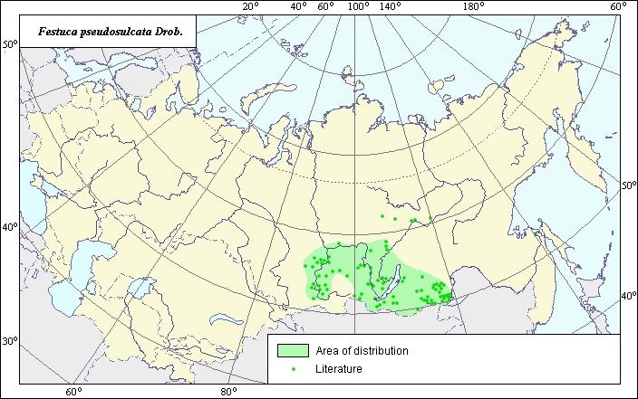
Distribution area of false striated fescue (Festuca pseudosulcata) .
 Object description Download GIS-layers
The author:
Object expert and GIS-expert L.L. MalyshevDate of creation:
26.06.2004Scale:
1:20,000,000.Accuracy of map:
Map was created using maps of scale 1:2,000,000-1:11,250,000.Projection:
"Alber.s Equal Area Conic for the USSR", 9, 1001, 7, 100, 0, 44, 68, 0, 0.Basic contents:
Vector map consisting of 1 base and 2 thematic layers. The species distribution area is shown by polygons and points.Accuracy of qualifier:
Points represent sites from which BIN herbarium specimens were taken and species locations referenced in published literature. Polygons represent the general species distribution area, which was created by generalizing reference data.Mapping procedure:
The map is based on species locations provided by the BIN herbarium and published maps in Kharkevich (1985) and Malyshev & Peshkova (1979, 1990).The species occurs in steppe and forest-steppe zones in Yenisei and Angara, in steppe areas of Dauria, and on steppe slopes of mountains in Pribaikalye.
Sources of data:
Kharkevich S.S., ed. 1985. Vascular plants of the Soviet Far East. Vol. 1. The Science, 398 pages.Malyshev L.I., Peshkova G.A., eds. 1990. Flora of Siberia. Vol. 2. Poaceae (Gramineae.) Novosibirsk: Science, 361 pages.
Malyshev L.I., Peshkova G.A., eds. 1979. Flora of Central Siberia. Vol. 1. Onocleaceae-Saxifragaceae. Novosibirsk: Science, 431 pages.
Rights and copyrights:
All rights to this map and its descriptions belong to its author.Copyright on the photos belongs to E. Dzyubenko.