
Relatives
Distribution area of hard fescue (Festuca pseudovina) .
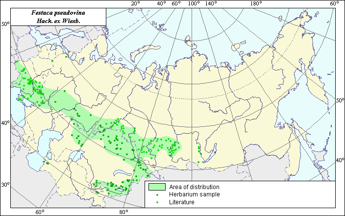 Object description Download GIS-layers
Authors:
Object experts L.L. Malyshev & N.Yu. MalyshevaGIS-expert L.L. Malyshev
Date of creation:
27.09.2004Scale:
1:20,000,000.Accuracy of map:
Map was created using maps of scale 1:2,000,000-1:11,250,000.Projection:
"Alber's Equal Area Conic for the USSR", 9, 1001, 7, 100, 0, 44, 68, 0, 0.Basic contents:
Vector map. Area of species distribution is shown by polygons, while actual location occurrence is shown by points.Accuracy of classifier:
Point data were obtained from published sources and herbarium specimens. Polygons are based on published sources, herbarium samples, and field surveys by the authors.Method of map production:
Published literature was reviewed, including atlases, monographs and papers. Occurrence data were obtained from herbarium specimens, floras, monographs and papers. Shelyag-Sossonko (1977) and Malyshev & Peshkova (1990) were used to determine the species distribution area. Data were then compiled through scanning and geo-referencing to develop a composite vector map. The biologist, together with the GIS-specialist, drew a new plant distribution area based on compiled data. Within the European part of the former USSR and Siberia, the species is distributed throughout steppe zones (except for dry steppes in the Lower Volga region). In Central Asia and Kazakhstan, it is found in the steppe zone, the middle belt of mountains in Tyan-Shang and in the mountains Ala Taus. In the Caucasus, the species has been replaced by Festuca callieri (Hack.) Markgr.Reference citations:
Malyshev, L.I. & G.A. Peshkova, eds. 1990. Flora of Siberia. V. 2. Poaceae (Gramineae). Novosibirsk: Nauka. 361 p.Shelyag-Sossonko Yu.R., ed. 1977. Cereals of Ukraine. Kiev: Naukova Dumka. 518 p.