
Relatives
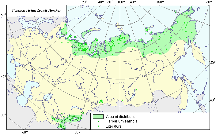
Distribution area of Richardson's fescue (Festuca richardssonii) .
 Object description Download GIS-layers
Author:
Object expert and GIS-expert L.L. MalyshevDate of creation:
27.09.2005Scale:
1:20,000,000.Accuracy of map:
Map was created using maps of scale 1:2,000,000-1:11,250,000.Projection:
"Alber.s Equal Area Conic for the USSR", 9, 1001, 7, 100, 0, 44, 68, 0, 0.Basic contents:
Vector map consisting of 1 base and 3 thematic layers. The distribution area of the species is shown by polygons and points.Accuracy of qualifier:
Points represent locations from which L.E. herbarium materials were taken and locations mentioned in published references. The polygon is based on generalized information on species distribution.Mapping procedure:
The species distribution area was determined using species locations reported by the L.E. herbarium and published maps from Malyshev & Peshkova (1990), Tolmatchev (1974), and Hulten & Fries (1986). The species distribution area covers the entire Arctic zone within the former USSR and the high-mountainous belt of Central Asia. Hulten and Fries (1986) consider Festuca richardsonii part of a complex of kriophil forms of Festuca rubra s.l., which incliudes F. cryophylla, F. kirilovii and some other species. The Soviet authors consider these subspecies of F. rubra - Festuca rubra subsp. arctica (or a special species Festuca arctica).Sources of data:
Hulten E., Fries M. 1986. Atlas of Northern European Vascular Plants North of the Tropic of Cancer. Vol. 1-3. Konigstein, 1172 p.Malyshev L.I., Peshkova G.A., eds. 1990. Flora of Siberia. Vol. 2. Poaceae (Gramineae). Novosibirsk, Nauka, 361 p. (In Russian).
Tolmatchev A.I., ed. 1974. Flora of the Northeast of the European part of the USSR. Vol. 1. Families Polypodiaceae - Gramineae. Leningrad, Nauka, 275 p. (In Russian).
Rights and copyrights:
All rights to the map and its descriptions belong to its author.Copyright on the photos belongs to E. Dzyubenko.