
Relatives
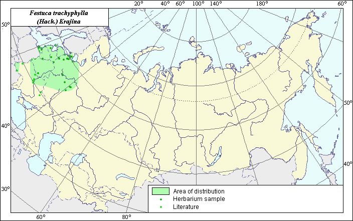
Distribution area of rough-leaf fescue (Festuca trachyphylla) .
 Object description Download GIS-layers
Authors:
Object experts L.L. Malyshev & N.J. MalyshevaGIS-expert L.L. Malyshev
Date of creation:
27.12.2004Scale:
1:20,000,000Accuracy of map:
Map was created using maps of scale 1:2,000,000-1:11,250,000.Projection:
"Alber's Equal Area Conic for the USSR", 9, 1001, 7, 100, 0, 44, 68, 0, 0.Basic contents:
Vector map. Area of species distribution is shown by polygons, wile actual location occurrence is shown by points.Accuracy of classifier:
Point data were obtained from published sources and herbarium specimens. Polygons are based on published sources, herbarium samples, and field surveys by the authors.Method of map production:
The following published literature was reviewed, including atlases, monographs and papers: Hulten & Fries (1986) and Shelyshag-Sosonko (1977). Occurrence data were obtained from herbarium specimens (V.L. Komarov Botanical Institute), floras, monographs and papers. Within the European part of the former USSR, this species is distributed throughout the western parts of wood and forest-steppe zones up to the Oka-Volga region. Separate distribution areas were found in the Zakarpatye and Donetsk range. Data were then compiled through scanning and geo-referencing to develop a composite vector map. The biologist, together with the GIS-specialist, drew a new plant distribution area based on compiled data.Reference citations:
Hulten E., Fries M. 1986. Atlas of Northern European Vascular Plants North of the Tropic of Cancer. Vol. 1-3. Konigstein. 1172 p.Shelyag-Sosonko Yu.R., ed. 1977. Cereals of Ukraine. Kiev: Naukova Dumka. 518 p.