
Relatives
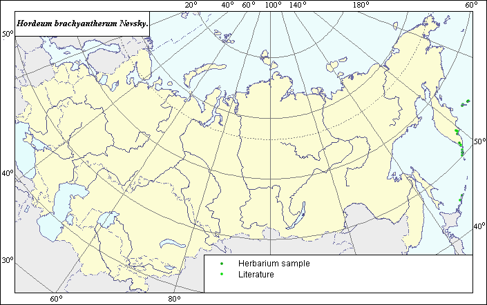
The distribution area of Hordeum brachyantherum Nevsky (Short-antheral barley) .
 Object description Download GIS-layers
Authors:
Expert-botanist T.N. SmekalovaGIS-expert R.S. Ushakova
Date of creation:
30.08.2005Scale:
1:20,000,000.Accuracy of map:
Map was created using maps of scale: 1:20,000,000 and data from herbarium specimens.The projection:
"Alber's Equal Area Conic for Russia", 9, 1001, 7, 100, 0, 44, 68, 0, 0.Basic content:
Map is a vector file consisting of points. Locations of species are represented by points.Accuracy of qualifier:
Light-colored points represent species locations referenced in published sources. Dark-colored points represent locations from which herbarium specimens were taken.Method of map construction:
The majority of the natural area of the species lies in the western part of North America. Within the former USSR, the species occurs in the northwest. The mapped distribution area consists of points representing species locations in the south of the Kamchatka peninsula and on the Kurilian and Komandorsky islands. The species distribution area was constructed using herbarium data (BIN, VIR, GBS) and Kharkevich (1987).Sources of data:
Cherepanov, S.K. 1995. Plantae Vasculares Rossicae et Civitatum Collimitanearum (in limicis USSR olim). St-Petersburg, Mir I Semia, 990 p. (in Russian).Herbarium Specimens. N.I. Vavilov All-Russian Institute of Plant Industry (St. Petersburg), Komarov Botanical Institute (St. Petersburg, Russia). Herbarium of the Main Botanical Garden (Moscow).
Kharkevich S.S., ed. 1987. Vascular plants of the Soviet Far East. Vol. 1. Leningrad: Nauka, 446 p. (in Russian).
Right and copyright:
Copyright on this map and its description belongs to its authors.Copyright on this image belongs to R.S. Ushakova.