
Relatives
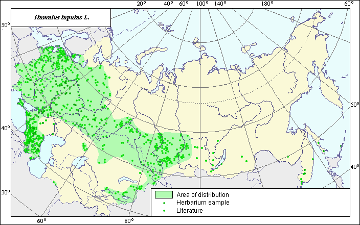
The area of Humulus lupulus L. (Common hop).
 Object description Download GIS-layers
Authors:
The expert-botanist - T.N. Smekalova,the GIS-expert - G.V. Talovina.
Date of creation:
06.09.2004.Scale:
1:20 000 000.Accuracy of a map:
Map is based on maps having the following scale: 1:10 000 000 - 80 000 000 and on data from herbarium specimans.The projection:
"Alber's Equal Area Conic for Russia", 9, 1001, 7, 100, 0, 44, 68, 0, 0Basic content:
Map is a vector fail consisting of polygon and points. Locations of species are represented by points, area of possible distribution of species are represented by polygon.Accuracy of the qualifier:
Lidht-colored points are locations referenced in literature sources. Dark-colored points are locations of species that were reported from herbarium samples. Polygon is based on generalized information from literature sources, herbarium specimans, political boundaries and ecological description.Method of map construction:
Locations and area of distribution of the species are based on published maps and analysis of herbarium materials from the Moscow State University, All-Russian Vavilov Institute ot Plant industry, Rostov State University, Uljanovsk Educational State University. Literature used included: Hulten (1986), Cherepanov (1995), Shmidt, Baranova and others (1990), Grossheim (1945), Tsvelev (2000), Kharkevitch (1991). Final area consists of main polygon, two small poligons and separated points. Our point of wiew as for Humulus lupulus distribution practically coincides with V.M. Shmidt.s and E. V. Baranova.s opinion of species area. Main poligon includes the large part of Europaean part of former USSR, the Caucasis, an goes behind the Ural mountains, including south part of western Sibiria and forest-meadow communities of the Soutth-Eastern part of the Middle Asia. The smallest polygon is situated in foothills of Kopet-Dag mountains. Set of the points on the end of south of Ural mountains is included into the second small polygon. separated points, not included into the polygons, are meaning second, invasive points of habitat. Acording to literature data (Kharkevitch, 1991), on the territory of Far East, the species is invasive and it is included into adventive fraction of flora.Sources of the data:
Areas of medicinal and related it plants of the USSR (the atlas), 1990. Shmidt V.M. (ed.), map of Humulus lupulus is constracted by Baranova E.V. and others - Leningrad: LGU. P. 80-81, 211.Cherepanov, S.K. 1995. Plantae Vasculares Rossicae et Civitatum Collimitanearum (in limicis USSR olim). St-Petersburg, "Mir I Semia", 990 p. (in Russian).
Flora USSR, 1939. Vol. V. Komarov V.L. (ed.) M.-L.: Publishing House of Acad. Science, pp. 382-383. (in Russian).
Galushko A.I. 1978. Flora of Northern Caucasia - Rostov, Publishing House of Rostov University, Vol.1, p. 198. (in Russian).
Grossgeim, A.A. 1945. Flora of Caucasia. Baku, Publishing House of Azerbaijan Acad. Science, Vol. III, 311 p., appendix. (in Russian).
Herbarium Specimans - Moscow State University (Russia), All-Russian Vavilov Institute ot Plant industry (SPb, Russia), Rostov State University (Russia), Uljanovsk Educational State University (Russia).
Hulten, Eric and Magnus Fries. 1986. Atlas of north European vascular plants north of the Tropic of Cancer.
Tsvelev, N.N. 2000. ManuaL of the vascular plants of North-West Russia (Leningrad, Pskov and Novgorod district). St.Petersburg, Publishing House of SPHFA, p. 410. (in Russian).
Vascular plants of the Soviet Far East, 1991, Vol. 5. Kharkevitch S.S. (ed.). Leningrad: Nauka, P. 102. (in Russian).
Right and copyright:
Copyright on this map and description belongs to its authors.Copyright on this picture belongs to Chukhina I.G.