
Relatives
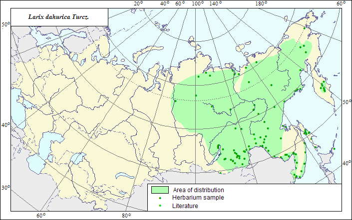
Range of distribution of Dahurian Larch (Larix dahurica) .
 Object description Download GIS-layers
Author:
The expert-botanist and the GIS expert - L.L.Malyshev.Date of creation:
29.03.2008Scale:
1:20 000 000Scale:
1:20 000 000.Accuracy of the map:
The map is based on data of 1:12 000 000-1:40 000 000 scale maps.Projection:
"Albers Equal-Area Conic Projection for USSR", 9, 1001, 7, 100, 0, 44, 68, 0, 0Basic contents:
The map is a vector file consisting of 1 basic and 3 subject layers. The species range is represented by a polygon and dots.Accuracy of the qualifier:
The dots represent information on the species localities according to LE herbarium materials (1) and published sources (2), the polygon - generalized information on the species distribution.Method of the map construction:
The range map is based on coordinates according to herbarium materials of V.L.Komarov Botanical Institute (LE) and published maps (Sokolov et al., 1977; Kharkevich, 1985). The western range border stretches along the Lena and the Yenisei watershed, the northern one from the Pyasina River to the lower Khatanga River and far eastwards along the limit of tundra, up to the middle course of the Anadyr River, from where the eastern border of the range goes to the coast of the Sea of Okhotsk and from the lower Uda River to the mouth of the Bureya River. In Primorie, occurs in the Ussuri River valley and at the coast of the Sea of Japan. Forms insular forests in Sakhalin and Kamchatka (middle course of the Kamchatka River). A number of authors treat the larch populations in the Far East as a separate species L. cajanderi Mayr.References:
Sokolov SI., Svjaseva OA., Kubli VA. 1977. Ranges of trees and shrubs of the USSR. V.1. Leningrad: Nauka. 240 p. (In Russian).Kharkevich SS., ed. 1985. Vascular plants of the Soviet Far East. V.1. Leningrad: Nauka. 398 p. (In Russian).