
Relatives
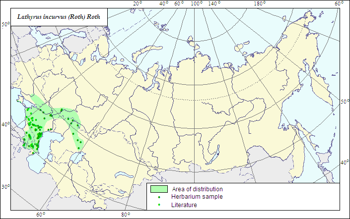
Range of distribution of Lathyrus incurvus (Roth) Roth (Incurved Pea)
 Object description Download GIS-layers
Authors:
The expert-botanist - T.N.Smekalova,the GIS expert - G.V.Talovina.
Date of creation:
18.04.2007Scale:
1:20 000 000.Accuracy of the map:
The map is based on data of a 1:10 000 000 scale map, corrected according to herbarium materials.Projection:
"Albers Equal-Area Conic Projection for USSR", 9, 1001, 7, 100, 0, 44, 68, 0, 0Basic contents:
The map is a vector file consisting of a polygon and dots. Point localities of the species are represented by dots, the area of possible species distribution is represented by the polygon.Accuracy of the qualifier:
Dark dots represent information on the species localities from herbarium specimens, the rest (light) dots represent data from published sources; the polygon is based on generalized information from published sources and herbarium specimens.Method of the map construction:
We accept the view of Z.V.Chefranova (Fedorov, Tzvelev, 1987) on the species distribution in the former USSR, and consider the species distributed in the Caucasus (except for Talysh), Central Asia (Aral-Caspian Lowland), in the Crimea and southern Russia. The species range is represented by two polygons, the main and the Crimean one. The Crimean polygon embraces the species localities in the southern, forest part of the Crimean Peninsula. The western border of the main polygon is drawn after published data (Shishkin, Bobrov, 1948; Fedorov, Tzvelev, 1987), the southern one coincides with the former state border of the USSR in the Caucasus area; the northern and the eastern are resulted from generalizations of data on the species localities in the Aral-Caspian region and southern Russia (herbarium data, ILDIS, Manual of Plants of Middle Asia, Pavlov, 1961), as well as published data (Mayevsky, 2006). The data on factual species localities are obtained from LE, WIR, MW, RV Herbaria, and from a published map of the species range (Grossheim, 1952).References:
Grossheim AA. 1952. Flora of Caucasus. 2nd ed. V.5. P.408, map. (In Russian).Mayevsky PF. 2006. Flora of the middle zone of European part of Russia. 10th ed. Moscow. P.336-338. (In Russian).
Fedorov AA., Tzvelev NN., eds. 1987. Flora of the European part of the USSR. V.6. Leningrad: Nauka. P.163. (In Russian).
Pavlov NV., ed. 1961. Flora of Kazakhstan. V.2. Alma-Ata. 515 p. (In Russian).
Shishkin BK., Bobrov EG., ed. 1948. Flora URSS. V.13. P.504-505. (In Russian).
Cherepanov SK. 1995. Vascular plants of Russia and adjacent states (the former USSR). St.Petersburg. 990 p. (In Russian).
Herbarium materials of V.L.Komarov Botanical institute [LE], St.Petersburg, N.I.Vavilov All-Russian Institute of Plant Industry [WIR], St.Petersburg, M.V.Lomonosov Moscow State University [MW], Moscow, Rostov State University [RV], Rostov-on-Don (all in Russia).