
Relatives
The distribution area of Lathyrus aleuticus (Greene) Pobed. (Aleutian grass pea).
 Object description Download GIS-layers
Authors:
Expert botanist T.N. SmekalovaGIS-expert R.S. Ushakova
Date of creation:
30.08.2005Scale:
1:20,000,000.Accuracy of map:
Map was created using maps of scale 1:20,000,000-1:80,000,000 and herbarium specimens.The projection:
"Alber's Equal Area Conic for Russia", 9, 1001, 7, 100, 0, 44, 68, 0, 0.Basic contents:
Map is a vector file consisting of points. Locations of species are represented by points.Accuracy of qualifier:
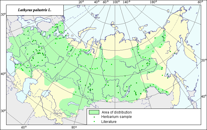
Light-colored points represent species locations referenced in published sources. Dark-colored points represent locations from which herbarium samples were taken.Method of map construction:
The species is distributed in places with excessive humidity throughout nearly the entire former USSR, except for the Far East, where it has been replaced by the closely related species L. pilosus, which many researchers do not consider an independent species but rather a subspecies of L. palustris. The distribution area consists of a polygon and separate points and was constructed by generalizing all available, published data on species distribution. Species distribution in the European part of the former USSR is limited in the south by droughty, dry steppes, deserts and semi-deserts and in the north by the tundra zone. In the Asian part, the species is distributed throughout Western and Central Siberia and separate regions of Eastern Siberia. The points not included in the polygon represent individual habitats outside the general distribution area. In order to construct the species distribution area, data from the VIR, Moscow State University, St. Petersburg State University, the Moscow Central Botanical Garden, Altajsky State Uninersity (Barnaul) herbariums and published maps of species distribution (Grossgeim, 1952; Moesel, 1965; Hulten & Fries, 1986; Tolmachev, 1976) were used.Sources of data:
Altajsky State University, Barnaul, Russia.Cherepanov S.K. 1995. Plantae Vasculares Rossicae et Civitatum Collimitanearum (in limics USSR olim). St. Petersburg, Mir I Semia, 990 p. (in Russian).
Grossgeim A.A. 1952. Flora of the Caucasus. Vol. 5. Moscow-Leningrad: Publishing House of the USSR Academy of Sciences, 424 p. (in Russian).
Herbarium of the Main Botanical Garden, Moscow, Russia.
Hulten E., Fries M. 1986. Atlas of Northern European Vascular Plants North of the Tropic of Cancer. Vol. 1-3. Koeltz Scientific Books, Konigstein.
Moesel H. 1965. Vergleichende Chorologie der Zentraleuropischen Flora. Jena, 583 p. (in German).
Moscow State University [MWG], Moscow, Russia.
N.I. Vavilov All-Russian Institute of Plant Industry [VIR], St. Petersburg, Russia.
Shishkin B.K., Bobrov E.G., eds. 1948. Flora of the USSR. Vol. 13. Moscow-Leningrad: Publishing House of Acad. Science, p. 391. (in Russian).
St. Petersburg State University, Russia.
Tolmachev A.I., ed. 1976. Flora of the Northeastern European part of the USSR. V. 3. Leningrad: Nauka, 293 p. (in Russian).