
Relatives
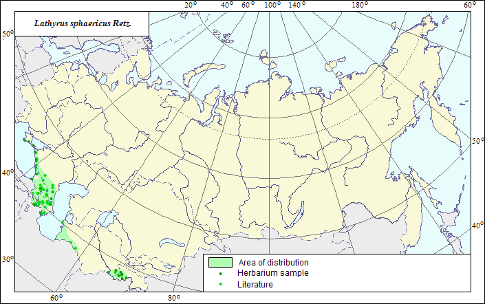
Range of distribution of Lathyrus sphaericus Retz.(Spring Vetchling).
 Object description Download GIS-layers
Authors:
The expert-botanist - T.N.Smekalova,the GIS expert - R.S.Ushakova.
Date of creation:
18.04.2007Scale:
1:20 000 000.Accuracy of the map:
The map is based on data of a 1:10 000 000 scale map, corrected according to herbarium materials.Projection:
"Albers Equal-Area Conic Projection for USSR", 9, 1001, 7, 100, 0, 44, 68, 0, 0Basic contents:
The map is a vector file consisting of polygons and dots. Point localities of the species are represented by dots, the area of possible species distribution is represented by the polygons.Accuracy of the qualifier:
Dark dots represent information on the species localities from herbarium specimens, the rest (light) dots represent data from published sources; the polygons are based on generalized information from published sources and herbarium specimens.Method of the map construction:
In the former USSR is the northeastern part of the species range. We accept the view by Z.V.Chefranova (Fedorov, Tzvelev, 1987) and the authors of "Manual of plants of Middle Asia" (Kamelin et al., 1981) on the species distribution in the former USSR, and consider the species distributed in foothills and low mountains of Caucasus, Crimea, Central Asia, and hardly penetrating both to arid desert and semidesert, and to humid plain areas. The species range is represented by four polygons, Crimean, Caucasian, and two Central Asian ones. The polygons are constructed according to factual (LE and WIR Herbaria) and published (Grossheim, 1952; Hulten, Fries, 1986; Ovczinnikov, 1978; Shishkin, Nikitin, 1950) data by means of their generalization. The Crimean polygon covers the species localities in the southern, forest part of Crimean Peninsula and is constructed according to herbarium data of LE and WIR. The borders of the Caucasian polygon are drawn according to published (Grossheim, 1952) and factual data. The southern borders of the Caucasian and Central Asian polygons coincide with the former state border of the USSR; the northern ones are drawn by means of generalization of all available data on the species localities.References:
Grossheim AA. 1952. Flora of Caucasus. 2nd ed. V.5. P.379. (In Russian).Kamelin RV., Kovalevskaya SS., Nabiev MM., eds. 1981. Manual of plants of Middle Asia. V.6. Tashkent. 395 p. (In Russian).
Ovczinnikov PN., ed. 1978. Flora of Tadzhik Soviet Socialist Republic. V.5. Leningrad: Nauka. 678 p. (In Russian).
Shishkin BK., Nikitin VV., eds. 1950. Flora of Turkmenia. V.5. Ashkhabad. (In Russian).
Cherepanov SK. 1995. Vascular plants of Russia and adjacent states (the former USSR). St.Petersburg. 990 p. (In Russian).
Herbarium materials of V.L.Komarov Botanical Institute [LE], N.I.Vavilov All-Russian Institute of Plant Industry [WIR], St.Petersburg, Russia.
Rights and copyrights:
The copyrights of the map and descriptions are held by their authors.The copyright of the photo is held by Jean Michaux ( http://crdp.ac-besancon.fr/flore/flore.htm ).