
Relatives
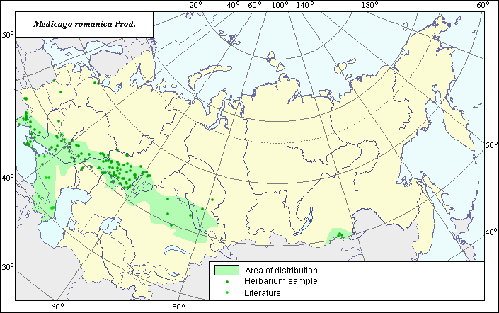
Distribution area of steppe medicago (Medicago romanica Prod.).
 Object description Download GIS-layers
Authors:
Experts N.I. Dzyubenko & E.A. DzyubenkoGIS-expert A.N. Dzyubenko
Date of creation:
17.09.2004Scale:
1:20,000,000Accuracy of map:
The map was created using maps of scale 1:10,000,000.The projection:
"Alber's Equal Area Conic for Russia", 9, 1001, 7, 100, 0, 44, 68, 0, 0.Basic contents:
Vector map. Area of species distribution is shown by polygons, while actual location occurrence is shown by points.Accuracy of classifier:
Point data were obtained from published sources and herbarium specimens. Polygons are based on published sources, herbarium samples, and field surveys by the authors. Light-colored points represent species locations referenced in published sources. Dark-colored points represent species locations reported in the VIR database (N.I. Vavilov Institute, 2003) and by the V.L. Komorov Institute of Botany.Method of map production:
Published literature was reviewed, including atlases, monographs and papers. Occurrence data were obtained from herbarium specimens, floras, monographs and papers. The following sources were used to determine the general distribution area: herbaria and databases of the N.I. Vavilov Institute of Plant Industry, the V.L. Komarov Botanical Institute, and Grossheim (1952). The point data of Medicago romanica mainly includes locations of the species identified through the VIR and BIN herbariums. The final species distribution area was constructed using Schischkin & Bobrov (1945), Pavlov (1961), Brezhnev & Korovina (1980), and Phyodorov (1987). The area has a disjunctive quality and consists of two polygons and separate points. The main polygon occupies the southern part of the European region of the former USSR (steppe zone), the Crimea, the Caucasus, the steppe zone and Northern Kazakhstan. The second polygon occupies the steppe region of Dauria. The points, which were not included in the polygons, represent secondary, invasive sites of the species. The distribution area borders take into account the specialized ecological preferences of the species. Data were then compiled through scanning and geo-referencing to develop a composite vector map. The biologist, together with the GIS-specialist, drew a new plant distribution area based on compiled data.Reference citations:
Brezhnev D.D., Korovina O.N. 1980. Wild relatives of the cultivated plants of flora of the USSR. Leningrad: Kolos. 376 pp. (In Russian)Grossheim A.A. 1952. Genus Medicago. Flora of the Caucasus. Vol. 5. Moscow- Leningrad: Academy of Science of the USSR. 177-192 p. (In Russian)
N.I. Vavilov Institute, Herbarium Department, 2003. Database of geographic coordinates (in house), St. Petersburg, Russia.
Pavlov N.B., ed. 1961. Flora of Kazakhstan. Vol. 5. Alma-Ata: AN KazSSR. 515 pp. (In Russian)
Phyodorov A.A., ed. 1987. Flora of the European part of the USSR. Vol. 6. 254 pp. (In Russian)
Schischkin V.K., Bobrov E.G., eds. 1945. Flora of the USSR. Vol. 11. Moscow-Leningrad: USSR. 129-176 p. (In Russian)
V.L. Komarov Institute of Botany [LE], St. Petersburg,
Rights and copyrights:
Copyright on the map and its description belongs to its authors.Copyright on the photos belongs to N.I. Dzyubenko.