
Relatives
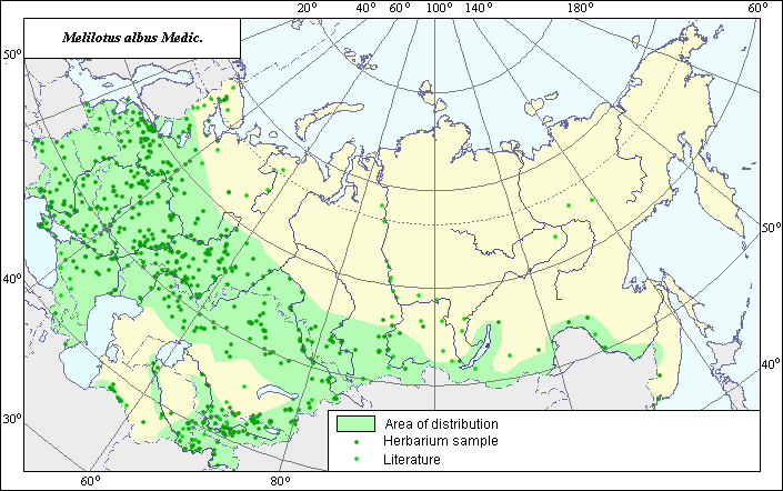
Distribution area of White sweet clover (Melilotus albus) .
 Object description Download GIS-layers
Authors:
Experts N.I. Dzyubenko & E.A. DzyubenkoGIS-expert A.N. Dzyubenko
Date of creation:
17.02.2005Scale:
1:20,000,000.Exactness of map:
The map was created using maps of scale 1:10,000,000-1:80,000,000.The projection:
"Alber's Equal Area Conic for Russia", 9, 1001, 7, 100, 0, 44, 68, 0, 0.Basic contents:
Map is a vector file consisting of polygons and points. Locations of species are represented by points, while the area of possible distribution of the species is represented by polygons.Exactness of classifier:
Light-colored points represent species locations referenced in published sources. Dark-colored points represent species locations reported in the VIR database (N.I. Vavilov All-Russian Research Institute of Plant Industry), the BIN database (the Komorov Institute of Botany) and the State University of Perm (SUP). Polygons are based on published sources, herbarium samples, political boundaries and ecological descriptions.Method of map construction:
To construct the distribution area of Melilotus albus, published maps of species distribution (Grossheim, 1952; Hulten & Fries, 1986) and herbaria data (Komarov Botanical Institute (BIN), N.I. Vavilov All-Russian Institute of Plant Industry (VIR), St. Petersburg) were used. The species distribution area was created by generalizing all available data to form the mapped polygon (green line). The distribution area borders were mapped using all available data. The final distribution area consists of three polygons and separate points. The main polygon includes a large section of the European part of the former USSR, the Crimea, the Caucasus and goes behind the Ural mountains, including the southern part of Western Siberia, Eastern Siberia, the greater part of the Central Asia (except deserts; the species occurs in river valleys only). The smallest polygon is situated in the foothills of the Kopet-Dag Mountains. The third polygon is situated in irrigated regions of the Amu-Darya River. The points, which were not included in the general distribution area, represent secondary sites of species origin. In the Far East, the species occurs very rarely and as an invasive species (Polozhiy & Malyshev, 1994).Sources of data:
Database of VIR materials (N.I. Vavilov All-Russian Institute of Plant Industry), BIN materials (Komorov Institute of Botany).Grossheim A.A. 1952. Genus Melilotus. Flora of the Caucasus. Vol. 5. M.-L.: Academy of Science of the USSR, p. 192-194. (in Russian). (in Russian).
Hulten E., Fries M. 1986. Atlas of Northern European Vascular Plants North of the Tropic of Cancer. Vol. 1-3. Konigstein, 1172 p.
Polozhiy A.B., Malyshev L.I., eds. 1994. Flora of Siberia. Vol. 9. Novosibirsk: Nauka, 280 pp. (in Russian).
Rights and copyrights:
Copyright on the map and its description belongs to its authors.Copyright on the photos belongs to N.I. Dzyubenko.