
Relatives
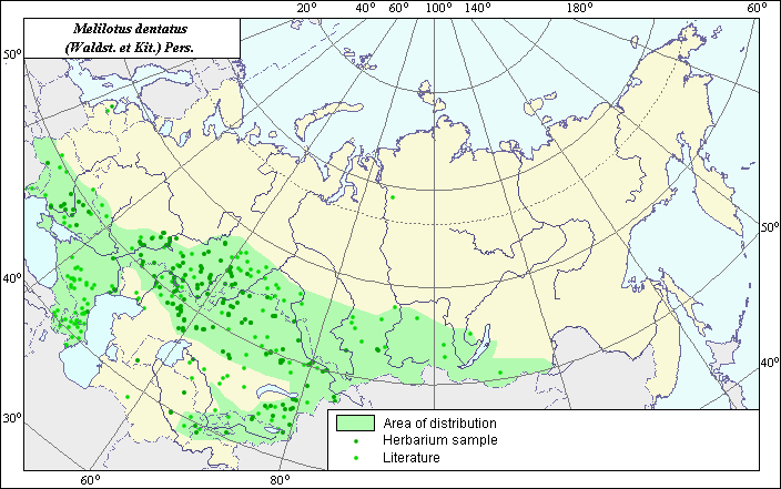
Distribution area of Dentated melilot (Melilotus dentatus) .
 Object description Download GIS-layers
Authors:
Experts N.I. Dzyubenko & E.A. DzyubenkoGIS-Expert A.N. Dzyubenko
Date of creation:
17.12.2004Scale:
1:20,000,000.Accuracy of map:
The map was created using maps of scale 1:10,000,000-1:80,000,000.The projection:
"Alber's Equal Area Conic for Russia", 9, 1001, 7, 100, 0, 44, 68, 0, 0.Basic contents:
Vector map. Area of species distribution is shown by polygons, while actual location occurrence is shown by points.Accuracy of classifier:
Point data were obtained from published sources and herbarium specimens. Polygons are based on published sources, herbarium samples, and field surveys by the authors. Light-colored points represent species locations referenced in published sources. Dark-colored points represent species locations reported in the VIR database (N.I. Vavilov Institute, 2003), the herbarium of the V.L. Komarov Institute of Botany and the State University of Perm.Method of map production:
Published literature was reviewed, including atlases, monographs and papers. Occurrence data were obtained from herbarium specimens, floras, monographs and papers. To construct the distribution area of Melilotus dentatus, the following published maps and herbaria were used: Grossheim (1952), Hulten & Fries (1986), Mosel (1965), the V.L. Komarov Botanical Institute, and the N.I. Vavilov Institute of Plant Industry. Our map of species distribution within Russia and the adjacent states partly coincides with that of Mosel (1965), with the exception of more accurate northern and southern borders and the extension of the area into the Caucasus. The distribution area consists of a polygon and separate points. The polygon includes the southern part of the European region of the former USSR, the Crimea, and the Caucasus and goes behind the Ural mountains, including the southern part of Western and Eastern Siberia and the greater part of Central Asia (except deserts; it occurs only in river valleys). Points not included in the polygon represent secondary, invasive sites of the species. Data were compiled through scanning and geo-referencing to develop a composite vector map. The biologist, together with the GIS-specialist, drew a new plant distribution area based on compiled data.Reference citations:
Grossgheim A.A. 1952. Genus Melilotus. Flora of the Caucasus. Vol. 5. Moscow-Leningrad: Academy of Science of the USSR. 192-194 p. (In Russian)Hulten E., Fries M. 1986. Atlas of Northern European Vascular Plants North of the Tropic of Cancer. Vol. 1-3. Konigstein, p. 1172.
Mosel H. 1965. Comparative Chorology of the Flora of Central Europe. Jena. 583 p.
N.I. Vavilov Institute, Herbarium Department, 2003. Database of geographic coordinates (in house), St. Petersburg, Russia.
State University of Perm [SUP], Perm, Russia.
V.L. Komarov Institute of Botany [WIR], St. Petersburg, Russia.
Rights and copyrights:
Copyright on the map and its description belongs to its authors.Copyright on the photos belongs to N.I. Dzyubenko.