
Relatives
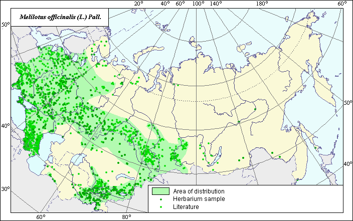
Distribution area of Yellow sweet clover (Melilotus officinalis) .
 Object description Download GIS-layers
Authors:
Experts N.I. Dzyubenko & E.A. DzyubenkoGIS-expert A.N. Dzyubenko
Date of creation:
17.12.2004Scale:
1:20,000,000Accuracy of map:
The map was created using maps of scale 1:10,000,000-1:80,000,000.The projection:
"Alber's Equal Area Conic for Russia", 9, 1001, 7, 100, 0, 44, 68, 0, 0.Basic contents:
Vector map. Area of species distribution is shown by polygons, while actual location occurrence is shown by points.Accuracy of classifier:
Point data were obtained from published sources and herbarium specimens. Polygons are based on published sources, herbarium samples, and field surveys by the authors. Light-colored points represent species locations referenced in published sources. Dark-colored points represent species locations reported in the VIR database (N.I. Vavilov Institute, 2003), the herbarium of the V.L. Komarov Institute of Botany and the State University of Perm.Method of map production:
Published literature was reviewed, including atlases, monographs and papers. Occurrence data were obtained from herbarium specimens, floras, monographs and papers. The following sources were used to determine the species distribution area: Grossheim A.A. (1952), Hulten & Fries (1986), Schmidt (1983) and herbarium data from the V.L. Komarov Botanical Institute, the N.I. Vavilov All-Russian Institute of Plant Industry and Perm State University (PSU). The main polygon includes a large part of the European part of the former USSR, the Crimea, the Caucasus and goes behind the Ural mountains, including the south part of Western Siberia and the greater part of Central Asia (except deserts, where the species occurs only in river valleys). The smallest polygon is situated in the foothills of the Kopet-Dag Mountain Range. The points, which were not included in the main distribution area, represent sites of the secondary origin of the species. In Eastern Siberia and the Far East, the species occurs very rarely and has an invasive character. Data were then compiled through scanning and geo-referencing to develop a composite vector map. The biologist, together with the GIS-specialist, drew a new plant distribution area based on compiled data.Reference citations:
Grossheim, A.A. 1952. Genus Melilotus. Flora of the Caucasus. Vol. 5. Moscow-Leningrad: Academy of Science of the USSR. 192-194 p. (In Russian).Hulten E., Fries M. 1986. Atlas of North European Vascular Plants North of the Tropic of Cancer. Vol. 1-3. Konigstein, 1172 p.
N.I. Vavilov Institute, Herbarium Department, 2003. Database of geographic coordinates (in house), St. Petersburg, Russia.
Schmidt V.M., ed. 1983. Areas of medical plants and their relatives of the USSR. Leningrad: Leningrad University Publishers. 340 pp.
V.L. Komarov Institute of Botany [LE], St. Petersburg, Russia.
Rights and copyrights:
Copyright on the map and its description belongs to its authors.Copyright on the photos belongs to N.I. Dzyubenko.