
Relatives
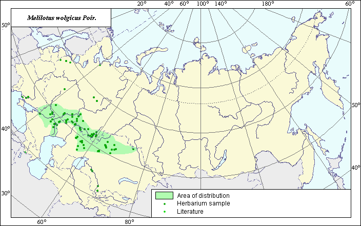
Distribution area of Russian melilot (Melilotus wolgicus) .
 Object description Download GIS-layers
Authors:
Experts N.I. Dzyubenko & E.A. DzyubenkoGIS-Expert A.N. Dzyubenko
Date of creation:
17.12.2004Scale:
1:20,000,000Accuracy of map:
The map was created using maps of scale 1:10,000,000.The projection:
"Alber's Equal Area Conic for Russia", 9, 1001, 7, 100, 0, 44, 68, 0, 0.Basic contents:
Vector map. Area of species distribution is shown by polygons, while actual location occurrence is shown by points.Accuracy of classifier:
Point data were obtained from published sources and herbarium specimens. Polygons are based on published sources, herbarium samples, and field surveys by the authors. Light-colored points represent species locations referenced in published sources. Dark-colored points represent species locations reported in the database of the V.L. Komarov Institute.Method of map production:
Published literature was reviewed, including atlases, monographs and papers. Occurrence data were obtained from herbarium specimens, floras, monographs and papers. To construct the species distribution area, herbarium data of the V.L. Komarov Botanical Institute and the published map by Grossheim (1952) were used. Point data for Melilotus wolgicus includes locations of the species identified through the V.L. Komarov herbarium. The final species distribution area was constructed by compiling known point locations of the species with the following published data: Grossheim (1945), Suvorov (1950), Pavlov (1961), Brezhnev & Korovina (1980), and Phyodorov (1987). The resulting area is a polygon (green line). The distribution area borders are based on all available data. The points, which were not included in the polygon, represent secondary, invasive sites of the species. The border of the distribution area also takes into account the specialized ecological preferences of the species. The single location of the species in the Southern Caucasus (Ordud, according to Grossheim, 1952) can be considered invasive (Grossheim, 1945). Data were then compiled through scanning and geo-referencing to develop a composite vector map. The biologist, together with the GIS-specialist, drew a new plant distribution area based on compiled data.Reference citations:
Brezhnev D.D., Korovina O.N. 1980. Wild relatives of the cultivated plants of flora of the USSR. Leningrad: Kolos. 376 pp. (In Russian)Grossheim A.A. 1945. Genus Melilotus. Flora of the USSR. Vol. 11. Moscow-Leningrad: USSR. 176-189 p. (In Russian)
Grossheim A.A. 1952. Genus Melilotus. Flora of the Caucasus. Vol. 5. Moscow- Leningrad: Academy of Science of the USSR. 192-194 p. (In Russian)
Pavlov N.B., ed. 1961. Flora of Kazakhstan. Vol. 5. Alma-Ata: AN KazSSR. 515 pp. (In Russian)
Phyodorov A.A., ed. 1987. Flora of the European part of the USSR. Vol. 6. 254 pp. (In Russian)
Suvorov V.V. 1950. Genus Melilotus. Flora of cultivated plants of the USSR. Vol. 13. Moscow-Leningrad. Issue 1. 345-502 p. (In Russian)
V.L. Komarov Institute of Botany [LE], St. Petersburg, Russia.
Rights and copyrights:
Copyright on the map and its description belongs to its authors.Copyright on the photos belongs to N.I. Dzyubenko.