
Relatives
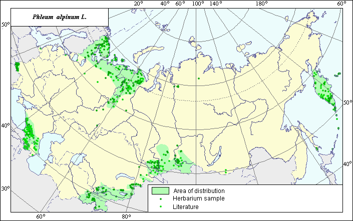
Distribution area of Alpine timothy (Phleum alpinum L.).
 Object description Download GIS-layers
Authors:
Experts N.I. Dzyubenko & E.A. DzyubenkoGIS-expert A.N. Dzyubenko
Date of creation:
17.09.2005Scale:
1:20,000,000.Exactness of map:
The map was created using maps of scale 1:10,000,000-1:80,000,000.The projection:
"Alber's Equal Area Conic for Russia", 9, 1001, 7, 100, 0, 44, 68, 0, 0.Basic contents:
Map is a vector file consisting of polygons and points. Locations of the species are represented by points, while the area of possible distribution of the species is represented by polygons.Exactness of classifier:
Light-colored points represent species locations referenced in published sources. Dark-colored points represent species locations reported in the VIR database (N.I. Vavilov All-Russian Research Institute of Plant Industry) and the BIN database (the Komorov Institute of Botany). Polygons are based on published sources, herbarium samples, political boundaries and ecological descriptions.Method of map construction:
To construct the distribution area of Phleum alpinum, published maps of species distribution (Grossheim, 1939; Tolmachev, 1964; Grasses of Ukraine, 1977; Harkevich, 1985; Hulten & Fries, 1986; Malyshev & Peshkova, 1990) and herbaria data (Komarov Botanical Institute (BIN), N.I. Vavilov All-Russian Institute of Plant Industry (VIR), St. Petersburg), were used. The species distribution localized mainly in mountainous regions of former USSR. The presented distribution area, created by generalizing data, consists of ten polygons (green line) and separate points that correspond to published data on species distribution (Rodjevitz & Schischkin, 1937; Fedorov, 1974; Tzvelev, 1976). The largest polygon is situated in the north of European Russia and near the Ural Mountains. The next two polygons cover the Carpathian Mountains and the Caucasian Mountains; the following three polygons cover the mountains of Central Asia and Altai. The next three polygons cover Kamchatka and the islands of the Far East. The last polygon is situated on Kolguev Island (Barents Sea). The distribution area borders are based on all available data. The points, which were not included in the polygons, represent single sites of the species. The distribution area borders take into account the ecological preferences of the species.Sources of data:
Cereals of Ukraine. 1977. Kiev: Naukova Dumka, 518 pp. (in Russian).Database of VIR materials (N.I. Vavilov All-Russian Institute of Plant Industry) and BIN materials (Komorov Institute of Botany).
Fedorov A.A., ed. 1974. Flora of the European part of the USSR. Vol. 1. Leningrad: Nauka. 404 pp. (In Russian)
Grossheim A.A. 1939. Flora of the Caucasus. Vol. 2. Baku: AzFAN, pp. 587. (in Russian).
Harkevich S.S., ed. 1985. Vascular Plants of the Soviet Far East. Vol. 1. St. Petersburg: Nauka, 390 p. (in Russian).
Hulten E., Fries M. 1986. Atlas of northern European vascular plants north of the Tropic of Cancer. Vol. 1-3. Konigstein, 1172 pp.
Malyshev L.I., Peshkova G.A., eds. 1990. Flora of Siberia. Vol. 2. Novosibirsk: Nauka, 361 pp. (in Russian).
Rodjevitz P.U., Schischkin V.K., eds. 1937. Flora of the USSR. Vol. 2. Moscow-Leningrad: USSR. 778 pp. (In Russian)
Tolmachev A.I., ed. 1964. Arctic flora of the USSR. Vol. 2. M.-L.: Nauka, 273 p. (in Russian).
Tzvelev N.N. 1976. Poaceae USSR. Leningrad: Nauka. 788 pp. (In Russian)
Rights and copyrights:
Copyright on the map and its description belongs to its authors.Copyright on the photos belongs to N.I. Dzyubenko.